You are here: Home > Network List > O2 - Oklahoma Consolidated Temporary Seismic Networks Stations List
> Station SC16 Oakwood, Oklahoma, USA > Earthquake Result Viewer
SC16 Oakwood, Oklahoma, USA - Earthquake Result Viewer
| Earthquake location: |
Near East Coast Of Honshu, Japan |
| Earthquake latitude/longitude: |
38.1/141.8 |
| Earthquake time(UTC): |
2021/05/01 (121) 01:27:30 GMT |
| Earthquake Depth: |
56 km |
| Earthquake Magnitude: |
6.6 Mi |
| Earthquake Catalog/Contributor: |
NEIC PDE/at |
|
| Network: |
O2 Oklahoma Consolidated Temporary Seismic Networks |
| Station: |
SC16 Oakwood, Oklahoma, USA |
| Lat/Lon: |
35.97 N/98.82 W |
| Elevation: |
500 m |
|
| Distance: |
87.4 deg |
| Az: |
45.033 deg |
| Baz: |
316.516 deg |
| Ray Param: |
0.043258186 |
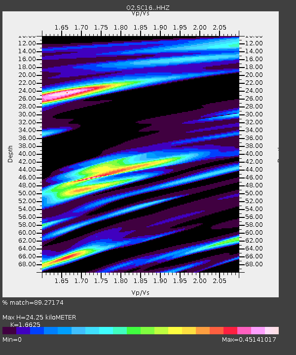
| Estimated Moho Depth: |
24.25 km |
| Estimated Crust Vp/Vs: |
1.66 |
| Assumed Crust Vp: |
6.315 km/s |
| Estimated Crust Vs: |
3.799 km/s |
| Estimated Crust Poisson's Ratio: |
0.22 |
|
| Radial Match: |
89.27174 % |
| Radial Bump: |
367 |
| Transverse Match: |
72.6625 % |
| Transverse Bump: |
400 |
| SOD ConfigId: |
24334971 |
| Insert Time: |
2021-05-15 01:55:50.066 +0000 |
| GWidth: |
2.5 |
| Max Bumps: |
400 |
| Tol: |
0.001 |
|

Signal To Noise
| Channel | StoN | STA | LTA |
| O2:SC16: :HHZ:20210501T01:39:39.969971Z | 7.991805 | 1.6900143E-6 | 2.114684E-7 |
| O2:SC16: :HHN:20210501T01:39:39.969971Z | 2.8213642 | 6.049816E-7 | 2.1442875E-7 |
| O2:SC16: :HHE:20210501T01:39:39.969971Z | 1.6615585 | 5.062341E-7 | 3.0467424E-7 |
| Arrivals |
| Ps | 2.6 SECOND |
| PpPs | 10.0 SECOND |
| PsPs/PpSs | 13 SECOND |


