You are here: Home > Network List > O2 - Oklahoma Consolidated Temporary Seismic Networks Stations List
> Station SMNL Seminole, Oklahoma, USA > Earthquake Result Viewer
SMNL Seminole, Oklahoma, USA - Earthquake Result Viewer
| Earthquake location: |
Near East Coast Of Honshu, Japan |
| Earthquake latitude/longitude: |
38.1/141.8 |
| Earthquake time(UTC): |
2021/05/01 (121) 01:27:30 GMT |
| Earthquake Depth: |
56 km |
| Earthquake Magnitude: |
6.6 Mi |
| Earthquake Catalog/Contributor: |
NEIC PDE/at |
|
| Network: |
O2 Oklahoma Consolidated Temporary Seismic Networks |
| Station: |
SMNL Seminole, Oklahoma, USA |
| Lat/Lon: |
35.29 N/96.56 W |
| Elevation: |
317 m |
|
| Distance: |
89.1 deg |
| Az: |
44.15 deg |
| Baz: |
317.795 deg |
| Ray Param: |
0.041974597 |
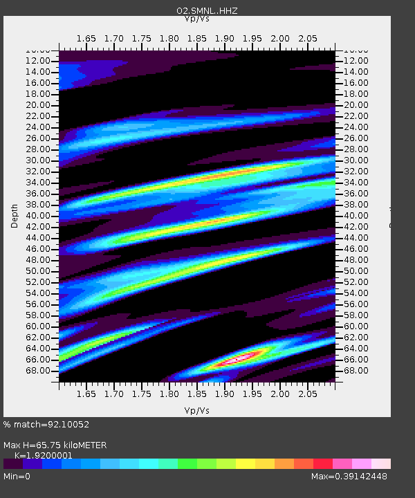
| Estimated Moho Depth: |
65.75 km |
| Estimated Crust Vp/Vs: |
1.92 |
| Assumed Crust Vp: |
6.426 km/s |
| Estimated Crust Vs: |
3.347 km/s |
| Estimated Crust Poisson's Ratio: |
0.31 |
|
| Radial Match: |
92.10052 % |
| Radial Bump: |
398 |
| Transverse Match: |
80.46533 % |
| Transverse Bump: |
343 |
| SOD ConfigId: |
24334971 |
| Insert Time: |
2021-05-15 01:55:56.501 +0000 |
| GWidth: |
2.5 |
| Max Bumps: |
400 |
| Tol: |
0.001 |
|

Signal To Noise
| Channel | StoN | STA | LTA |
| O2:SMNL: :HHZ:20210501T01:39:48.219971Z | 13.848152 | 1.5958879E-6 | 1.1524193E-7 |
| O2:SMNL: :HHN:20210501T01:39:48.219971Z | 2.4300478 | 3.3268475E-7 | 1.3690462E-7 |
| O2:SMNL: :HHE:20210501T01:39:48.219971Z | 3.6001348 | 6.428937E-7 | 1.785749E-7 |
| Arrivals |
| Ps | 9.6 SECOND |
| PpPs | 29 SECOND |
| PsPs/PpSs | 39 SECOND |


