You are here: Home > Network List > O2 - Oklahoma Consolidated Temporary Seismic Networks Stations List
> Station CVNG Covington, Oklahoma, USA > Earthquake Result Viewer
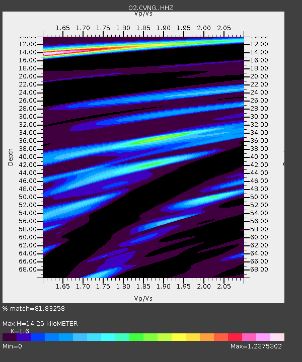
CVNG Covington, Oklahoma, USA - Earthquake Result Viewer
| Earthquake location: |
Near East Coast Of Honshu, Japan |
| Earthquake latitude/longitude: |
38.1/141.8 |
| Earthquake time(UTC): |
2021/05/01 (121) 01:27:30 GMT |
| Earthquake Depth: |
56 km |
| Earthquake Magnitude: |
6.6 Mi |
| Earthquake Catalog/Contributor: |
NEIC PDE/at |
|
| Network: |
O2 Oklahoma Consolidated Temporary Seismic Networks |
| Station: |
CVNG Covington, Oklahoma, USA |
| Lat/Lon: |
36.32 N/97.43 W |
| Elevation: |
358 m |
|
| Distance: |
87.9 deg |
| Az: |
43.982 deg |
| Baz: |
317.284 deg |
| Ray Param: |
0.042880632 |
| Estimated Moho Depth: |
14.25 km |
| Estimated Crust Vp/Vs: |
1.60 |
| Assumed Crust Vp: |
6.483 km/s |
| Estimated Crust Vs: |
4.052 km/s |
| Estimated Crust Poisson's Ratio: |
0.18 |
|
| Radial Match: |
81.83258 % |
| Radial Bump: |
351 |
| Transverse Match: |
62.318634 % |
| Transverse Bump: |
400 |
| SOD ConfigId: |
24334971 |
| Insert Time: |
2021-05-15 01:56:04.645 +0000 |
| GWidth: |
2.5 |
| Max Bumps: |
400 |
| Tol: |
0.001 |
|

Signal To Noise
| Channel | StoN | STA | LTA |
| O2:CVNG: :HHZ:20210501T01:39:42.419983Z | 12.668817 | 1.8916055E-6 | 1.4931194E-7 |
| O2:CVNG: :HHN:20210501T01:39:42.419983Z | 2.1513908 | 4.4181007E-7 | 2.0536021E-7 |
| O2:CVNG: :HHE:20210501T01:39:42.419983Z | 2.0832002 | 5.855637E-7 | 2.8108855E-7 |
| Arrivals |
| Ps | 1.4 SECOND |
| PpPs | 5.6 SECOND |
| PsPs/PpSs | 6.9 SECOND |


