You are here: Home > Network List > RV - Regional Alberta Seismic Observatory for Earthquake Studies Network Stations List
> Station BDMTA Bald Mountain Lookout Tower, AB > Earthquake Result Viewer
BDMTA Bald Mountain Lookout Tower, AB - Earthquake Result Viewer
| Earthquake location: |
Near East Coast Of Honshu, Japan |
| Earthquake latitude/longitude: |
38.1/141.8 |
| Earthquake time(UTC): |
2021/05/01 (121) 01:27:30 GMT |
| Earthquake Depth: |
56 km |
| Earthquake Magnitude: |
6.6 Mi |
| Earthquake Catalog/Contributor: |
NEIC PDE/at |
|
| Network: |
RV Regional Alberta Seismic Observatory for Earthquake Studies Network |
| Station: |
BDMTA Bald Mountain Lookout Tower, AB |
| Lat/Lon: |
54.81 N/118.91 W |
| Elevation: |
935 m |
|
| Distance: |
64.7 deg |
| Az: |
39.188 deg |
| Baz: |
300.546 deg |
| Ray Param: |
0.05863533 |
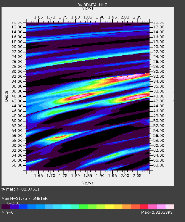
| Estimated Moho Depth: |
31.75 km |
| Estimated Crust Vp/Vs: |
2.01 |
| Assumed Crust Vp: |
6.161 km/s |
| Estimated Crust Vs: |
3.065 km/s |
| Estimated Crust Poisson's Ratio: |
0.34 |
|
| Radial Match: |
80.37631 % |
| Radial Bump: |
400 |
| Transverse Match: |
66.337006 % |
| Transverse Bump: |
400 |
| SOD ConfigId: |
24334971 |
| Insert Time: |
2021-05-15 01:58:46.223 +0000 |
| GWidth: |
2.5 |
| Max Bumps: |
400 |
| Tol: |
0.001 |
|

Signal To Noise
| Channel | StoN | STA | LTA |
| RV:BDMTA: :HHZ:20210501T01:37:31.429993Z | 17.76734 | 2.8767172E-6 | 1.6191039E-7 |
| RV:BDMTA: :HHN:20210501T01:37:31.429993Z | 2.8871315 | 8.3683153E-7 | 2.8984877E-7 |
| RV:BDMTA: :HHE:20210501T01:37:31.429993Z | 3.2368114 | 8.8747356E-7 | 2.7418142E-7 |
| Arrivals |
| Ps | 5.4 SECOND |
| PpPs | 15 SECOND |
| PsPs/PpSs | 20 SECOND |


