You are here: Home > Network List > TA - USArray Transportable Network (new EarthScope stations) Stations List
> Station A36M Sachs Harbour, NT, CAN > Earthquake Result Viewer
A36M Sachs Harbour, NT, CAN - Earthquake Result Viewer
| Earthquake location: |
Near East Coast Of Honshu, Japan |
| Earthquake latitude/longitude: |
38.1/141.8 |
| Earthquake time(UTC): |
2021/05/01 (121) 01:27:30 GMT |
| Earthquake Depth: |
56 km |
| Earthquake Magnitude: |
6.6 Mi |
| Earthquake Catalog/Contributor: |
NEIC PDE/at |
|
| Network: |
TA USArray Transportable Network (new EarthScope stations) |
| Station: |
A36M Sachs Harbour, NT, CAN |
| Lat/Lon: |
71.99 N/125.25 W |
| Elevation: |
32 m |
|
| Distance: |
55.2 deg |
| Az: |
22.245 deg |
| Baz: |
286.26 deg |
| Ray Param: |
0.064835295 |
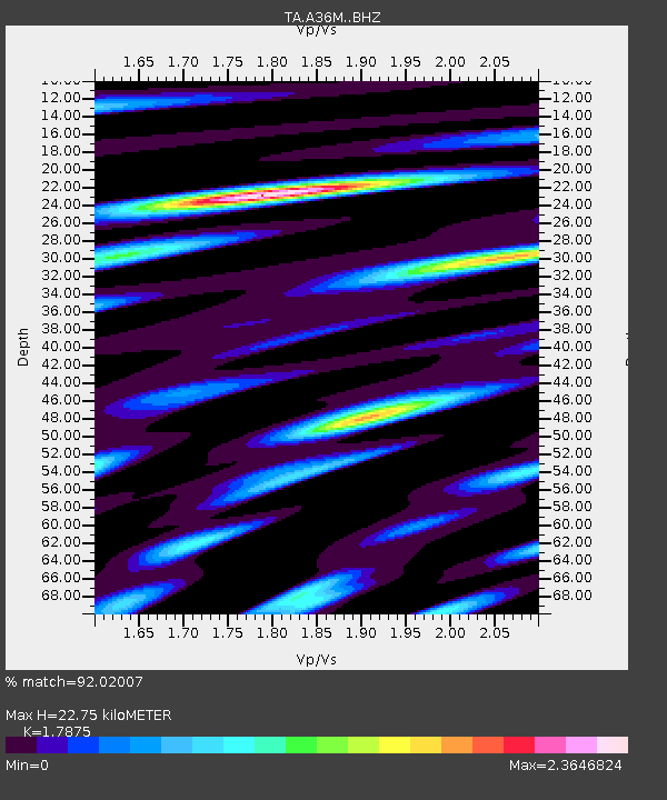
| Estimated Moho Depth: |
22.75 km |
| Estimated Crust Vp/Vs: |
1.79 |
| Assumed Crust Vp: |
6.24 km/s |
| Estimated Crust Vs: |
3.491 km/s |
| Estimated Crust Poisson's Ratio: |
0.27 |
|
| Radial Match: |
92.02007 % |
| Radial Bump: |
400 |
| Transverse Match: |
79.5604 % |
| Transverse Bump: |
400 |
| SOD ConfigId: |
24334971 |
| Insert Time: |
2021-05-15 01:59:50.776 +0000 |
| GWidth: |
2.5 |
| Max Bumps: |
400 |
| Tol: |
0.001 |
|
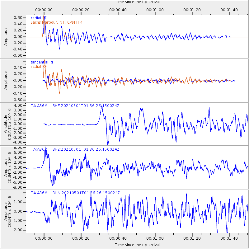
Signal To Noise
| Channel | StoN | STA | LTA |
| TA:A36M: :BHZ:20210501T01:36:26.150024Z | 63.353455 | 4.7304375E-6 | 7.46674E-8 |
| TA:A36M: :BHN:20210501T01:36:26.150024Z | 9.715116 | 7.273369E-7 | 7.486653E-8 |
| TA:A36M: :BHE:20210501T01:36:26.150024Z | 37.33959 | 2.5475163E-6 | 6.822561E-8 |
| Arrivals |
| Ps | 3.0 SECOND |
| PpPs | 9.7 SECOND |
| PsPs/PpSs | 13 SECOND |


