You are here: Home > Network List > TA - USArray Transportable Network (new EarthScope stations) Stations List
> Station C36M Paulatuk, NT, CAN > Earthquake Result Viewer
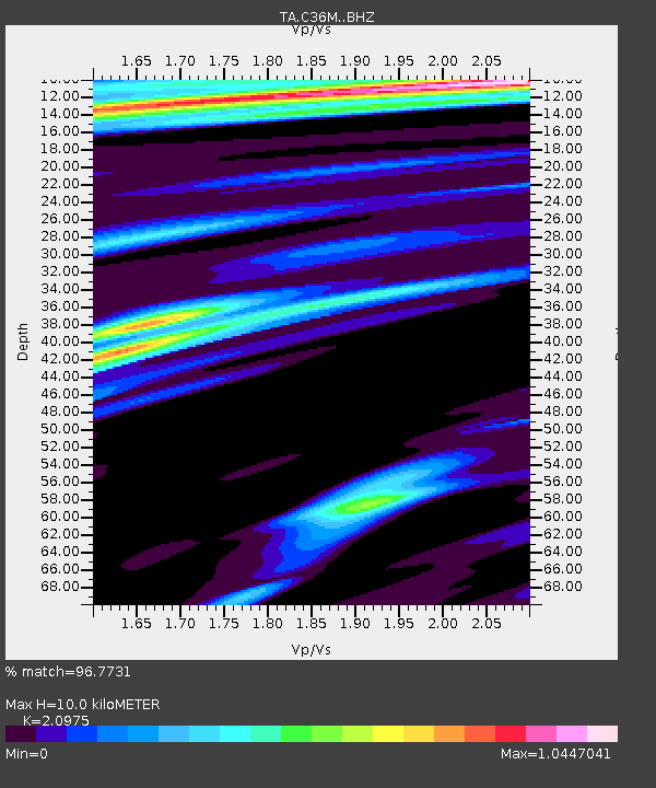
C36M Paulatuk, NT, CAN - Earthquake Result Viewer
| Earthquake location: |
Near East Coast Of Honshu, Japan |
| Earthquake latitude/longitude: |
38.1/141.8 |
| Earthquake time(UTC): |
2021/05/01 (121) 01:27:30 GMT |
| Earthquake Depth: |
56 km |
| Earthquake Magnitude: |
6.6 Mi |
| Earthquake Catalog/Contributor: |
NEIC PDE/at |
|
| Network: |
TA USArray Transportable Network (new EarthScope stations) |
| Station: |
C36M Paulatuk, NT, CAN |
| Lat/Lon: |
69.35 N/124.07 W |
| Elevation: |
10 m |
|
| Distance: |
56.3 deg |
| Az: |
25.161 deg |
| Baz: |
289.011 deg |
| Ray Param: |
0.06407051 |
| Estimated Moho Depth: |
10.0 km |
| Estimated Crust Vp/Vs: |
2.10 |
| Assumed Crust Vp: |
6.459 km/s |
| Estimated Crust Vs: |
3.08 km/s |
| Estimated Crust Poisson's Ratio: |
0.35 |
|
| Radial Match: |
96.7731 % |
| Radial Bump: |
351 |
| Transverse Match: |
78.13002 % |
| Transverse Bump: |
400 |
| SOD ConfigId: |
24334971 |
| Insert Time: |
2021-05-15 01:59:51.547 +0000 |
| GWidth: |
2.5 |
| Max Bumps: |
400 |
| Tol: |
0.001 |
|

Signal To Noise
| Channel | StoN | STA | LTA |
| TA:C36M: :BHZ:20210501T01:36:34.575012Z | 40.559288 | 4.8062598E-6 | 1.18499614E-7 |
| TA:C36M: :BHN:20210501T01:36:34.575012Z | 8.655836 | 7.8427445E-7 | 9.0606434E-8 |
| TA:C36M: :BHE:20210501T01:36:34.575012Z | 23.614302 | 1.8089105E-6 | 7.6602326E-8 |
| Arrivals |
| Ps | 1.8 SECOND |
| PpPs | 4.6 SECOND |
| PsPs/PpSs | 6.4 SECOND |


