You are here: Home > Network List > TD - TransAlta Monitoring Network Stations List
> Station TD004 Z > Earthquake Result Viewer
TD004 Z - Earthquake Result Viewer
| Earthquake location: |
Near East Coast Of Honshu, Japan |
| Earthquake latitude/longitude: |
38.1/141.8 |
| Earthquake time(UTC): |
2021/05/01 (121) 01:27:30 GMT |
| Earthquake Depth: |
56 km |
| Earthquake Magnitude: |
6.6 Mi |
| Earthquake Catalog/Contributor: |
NEIC PDE/at |
|
| Network: |
TD TransAlta Monitoring Network |
| Station: |
TD004 Z |
| Lat/Lon: |
53.47 N/114.63 W |
| Elevation: |
791 m |
|
| Distance: |
67.6 deg |
| Az: |
38.962 deg |
| Baz: |
303.923 deg |
| Ray Param: |
0.056773517 |
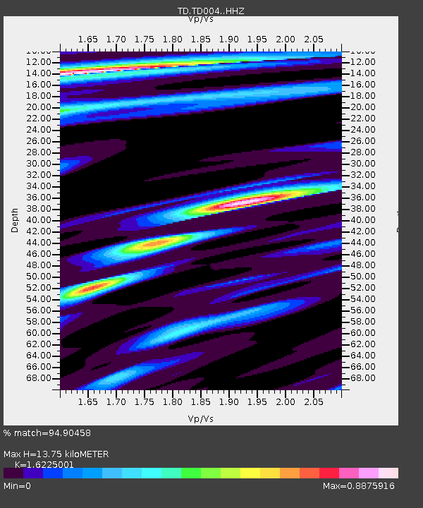
| Estimated Moho Depth: |
13.75 km |
| Estimated Crust Vp/Vs: |
1.62 |
| Assumed Crust Vp: |
6.426 km/s |
| Estimated Crust Vs: |
3.961 km/s |
| Estimated Crust Poisson's Ratio: |
0.19 |
|
| Radial Match: |
94.90458 % |
| Radial Bump: |
258 |
| Transverse Match: |
77.28625 % |
| Transverse Bump: |
400 |
| SOD ConfigId: |
24334971 |
| Insert Time: |
2021-05-15 02:00:18.100 +0000 |
| GWidth: |
2.5 |
| Max Bumps: |
400 |
| Tol: |
0.001 |
|

Signal To Noise
| Channel | StoN | STA | LTA |
| TD:TD004: :HHZ:20210501T01:37:49.659973Z | 16.978931 | 2.4109079E-6 | 1.4199408E-7 |
| TD:TD004: :HH1:20210501T01:37:49.659973Z | 0.887098 | 1.8119225E-7 | 2.0425279E-7 |
| TD:TD004: :HH2:20210501T01:37:49.659973Z | 4.5693293 | 1.3056169E-6 | 2.8573493E-7 |
| Arrivals |
| Ps | 1.4 SECOND |
| PpPs | 5.4 SECOND |
| PsPs/PpSs | 6.8 SECOND |


