You are here: Home > Network List > TD - TransAlta Monitoring Network Stations List
> Station TD007 Z > Earthquake Result Viewer
TD007 Z - Earthquake Result Viewer
| Earthquake location: |
Near East Coast Of Honshu, Japan |
| Earthquake latitude/longitude: |
38.1/141.8 |
| Earthquake time(UTC): |
2021/05/01 (121) 01:27:30 GMT |
| Earthquake Depth: |
56 km |
| Earthquake Magnitude: |
6.6 Mi |
| Earthquake Catalog/Contributor: |
NEIC PDE/at |
|
| Network: |
TD TransAlta Monitoring Network |
| Station: |
TD007 Z |
| Lat/Lon: |
52.91 N/115.62 W |
| Elevation: |
988 m |
|
| Distance: |
67.4 deg |
| Az: |
39.826 deg |
| Baz: |
303.464 deg |
| Ray Param: |
0.056894902 |
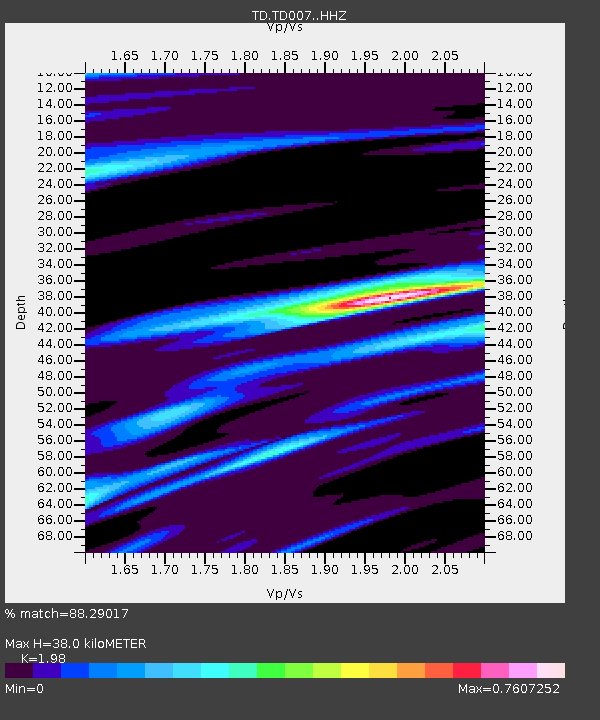
| Estimated Moho Depth: |
38.0 km |
| Estimated Crust Vp/Vs: |
1.98 |
| Assumed Crust Vp: |
6.426 km/s |
| Estimated Crust Vs: |
3.245 km/s |
| Estimated Crust Poisson's Ratio: |
0.33 |
|
| Radial Match: |
88.29017 % |
| Radial Bump: |
400 |
| Transverse Match: |
75.90041 % |
| Transverse Bump: |
400 |
| SOD ConfigId: |
24334971 |
| Insert Time: |
2021-05-15 02:00:20.984 +0000 |
| GWidth: |
2.5 |
| Max Bumps: |
400 |
| Tol: |
0.001 |
|

Signal To Noise
| Channel | StoN | STA | LTA |
| TD:TD007: :HHZ:20210501T01:37:48.51001Z | 15.980926 | 2.5626205E-6 | 1.6035494E-7 |
| TD:TD007: :HH1:20210501T01:37:48.51001Z | 3.9970262 | 7.0375535E-7 | 1.7606973E-7 |
| TD:TD007: :HH2:20210501T01:37:48.51001Z | 6.3883867 | 1.0444405E-6 | 1.6349048E-7 |
| Arrivals |
| Ps | 6.0 SECOND |
| PpPs | 17 SECOND |
| PsPs/PpSs | 23 SECOND |


