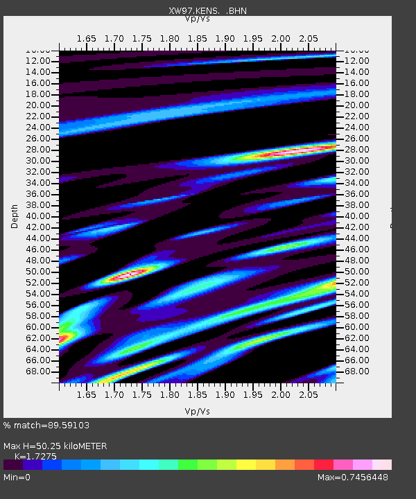
KENS XW.KENS - Earthquake Result Viewer
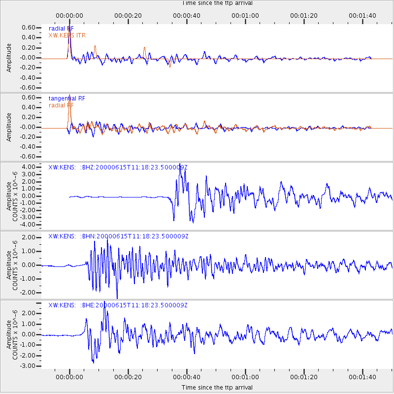
Earthquake location: Southeast Of Shikoku, Japan
Earthquake latitude/longitude: 29.4/132.1
Earthquake time(UTC): 2000/06/15 (167) 11:10:46 GMT
Earthquake Depth: 10 km
Earthquake Magnitude: 6.0 MB, 5.6 MS, 6.1 MW, 6.1 MW
Earthquake Catalog/Contributor: WHDF/NEIC
Network: XW Tien Shan Continental Dynamics
Station: KENS XW.KENS
Lat/Lon: 42.32 N/79.24 E
Elevation: 2805 m
Distance: 44.1 deg
Az: 301.834 deg
Baz: 89.323 deg
Ray Param: 0.07213244
Estimated Moho Depth: 50.25 km
Estimated Crust Vp/Vs: 1.73
Assumed Crust Vp: 6.306 km/s
Estimated Crust Vs: 3.65 km/s
Estimated Crust Poisson's Ratio: 0.25
Radial Match: 89.59103 %
Radial Bump: 400
Transverse Match: 66.29152 %
Transverse Bump: 400
SOD ConfigId: 20082
Insert Time: 2010-02-26 15:33:17.208 +0000
GWidth: 2.5
Max Bumps: 400
Tol: 0.001

Signal To Noise

ChannelStoNSTALTA
XW:KENS: :BHN:20000615T11:18:23.500009Z1.27343244.2378247E-83.327876E-8
XW:KENS: :BHE:20000615T11:18:23.500009Z3.26603468.936176E-82.7360937E-8
XW:KENS: :BHZ:20000615T11:18:23.500009Z4.52191351.8474891E-74.0856357E-8
Arrivals
Ps6.2 SECOND
PpPs20 SECOND
PsPs/PpSs27 SECOND