You are here: Home > Network List > TX - Texas Seismological Network Stations List
> Station MB04 Seminole > Earthquake Result Viewer
MB04 Seminole - Earthquake Result Viewer
| Earthquake location: |
Near East Coast Of Honshu, Japan |
| Earthquake latitude/longitude: |
38.1/141.8 |
| Earthquake time(UTC): |
2021/05/01 (121) 01:27:30 GMT |
| Earthquake Depth: |
56 km |
| Earthquake Magnitude: |
6.6 Mi |
| Earthquake Catalog/Contributor: |
NEIC PDE/at |
|
| Network: |
TX Texas Seismological Network |
| Station: |
MB04 Seminole |
| Lat/Lon: |
32.63 N/102.49 W |
| Elevation: |
956 m |
|
| Distance: |
87.7 deg |
| Az: |
49.547 deg |
| Baz: |
314.649 deg |
| Ray Param: |
0.04306948 |
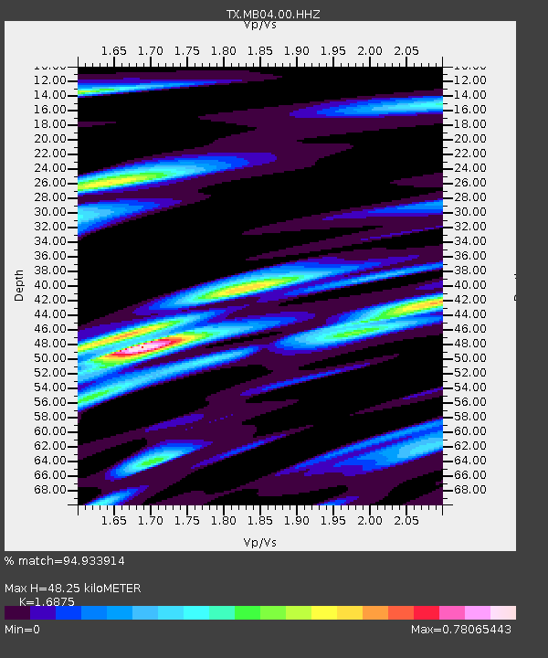
| Estimated Moho Depth: |
48.25 km |
| Estimated Crust Vp/Vs: |
1.69 |
| Assumed Crust Vp: |
6.129 km/s |
| Estimated Crust Vs: |
3.632 km/s |
| Estimated Crust Poisson's Ratio: |
0.23 |
|
| Radial Match: |
94.933914 % |
| Radial Bump: |
310 |
| Transverse Match: |
75.219246 % |
| Transverse Bump: |
400 |
| SOD ConfigId: |
24334971 |
| Insert Time: |
2021-05-15 02:01:10.112 +0000 |
| GWidth: |
2.5 |
| Max Bumps: |
400 |
| Tol: |
0.001 |
|

Signal To Noise
| Channel | StoN | STA | LTA |
| TX:MB04:00:HHZ:20210501T01:39:41.200012Z | 13.084553 | 7.4737403E-7 | 5.7118804E-8 |
| TX:MB04:00:HH1:20210501T01:39:41.200012Z | 2.7078774 | 2.6410115E-7 | 9.753068E-8 |
| TX:MB04:00:HH2:20210501T01:39:41.200012Z | 3.615937 | 1.9970693E-7 | 5.522965E-8 |
| Arrivals |
| Ps | 5.5 SECOND |
| PpPs | 21 SECOND |
| PsPs/PpSs | 26 SECOND |


