You are here: Home > Network List > TX - Texas Seismological Network Stations List
> Station MNHN Monahans > Earthquake Result Viewer
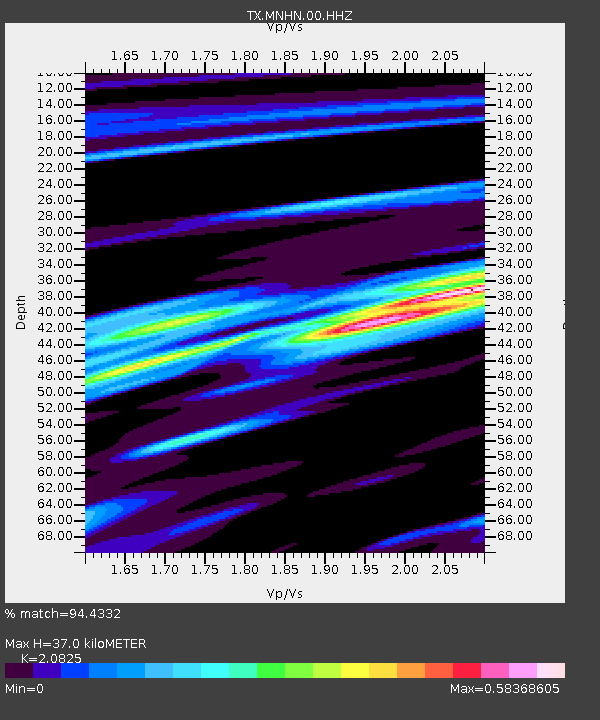
MNHN Monahans - Earthquake Result Viewer
| Earthquake location: |
Near East Coast Of Honshu, Japan |
| Earthquake latitude/longitude: |
38.1/141.8 |
| Earthquake time(UTC): |
2021/05/01 (121) 01:27:30 GMT |
| Earthquake Depth: |
56 km |
| Earthquake Magnitude: |
6.6 Mi |
| Earthquake Catalog/Contributor: |
NEIC PDE/at |
|
| Network: |
TX Texas Seismological Network |
| Station: |
MNHN Monahans |
| Lat/Lon: |
31.34 N/102.76 W |
| Elevation: |
750 m |
|
| Distance: |
88.4 deg |
| Az: |
50.623 deg |
| Baz: |
314.542 deg |
| Ray Param: |
0.042523477 |
| Estimated Moho Depth: |
37.0 km |
| Estimated Crust Vp/Vs: |
2.08 |
| Assumed Crust Vp: |
6.121 km/s |
| Estimated Crust Vs: |
2.939 km/s |
| Estimated Crust Poisson's Ratio: |
0.35 |
|
| Radial Match: |
94.4332 % |
| Radial Bump: |
288 |
| Transverse Match: |
84.77021 % |
| Transverse Bump: |
400 |
| SOD ConfigId: |
24334971 |
| Insert Time: |
2021-05-15 02:01:16.004 +0000 |
| GWidth: |
2.5 |
| Max Bumps: |
400 |
| Tol: |
0.001 |
|

Signal To Noise
| Channel | StoN | STA | LTA |
| TX:MNHN:00:HHZ:20210501T01:39:44.684998Z | 12.824135 | 1.2316075E-6 | 9.603825E-8 |
| TX:MNHN:00:HH1:20210501T01:39:44.684998Z | 2.0854304 | 2.3460004E-7 | 1.1249478E-7 |
| TX:MNHN:00:HH2:20210501T01:39:44.684998Z | 7.766142 | 4.0315925E-7 | 5.1912423E-8 |
| Arrivals |
| Ps | 6.7 SECOND |
| PpPs | 18 SECOND |
| PsPs/PpSs | 25 SECOND |


