You are here: Home > Network List > IU - Global Seismograph Network (GSN - IRIS/USGS) Stations List
> Station LSZ Lusaka, Zambia > Earthquake Result Viewer
LSZ Lusaka, Zambia - Earthquake Result Viewer
| Earthquake location: |
Eastern Xizang-India Border Reg. |
| Earthquake latitude/longitude: |
29.8/95.0 |
| Earthquake time(UTC): |
2017/11/17 (321) 22:34:19 GMT |
| Earthquake Depth: |
8.0 km |
| Earthquake Magnitude: |
6.4 Mww |
| Earthquake Catalog/Contributor: |
NEIC PDE/us |
|
| Network: |
IU Global Seismograph Network (GSN - IRIS/USGS) |
| Station: |
LSZ Lusaka, Zambia |
| Lat/Lon: |
15.28 S/28.19 E |
| Elevation: |
1200 m |
|
| Distance: |
78.4 deg |
| Az: |
244.906 deg |
| Baz: |
54.631 deg |
| Ray Param: |
0.04964881 |
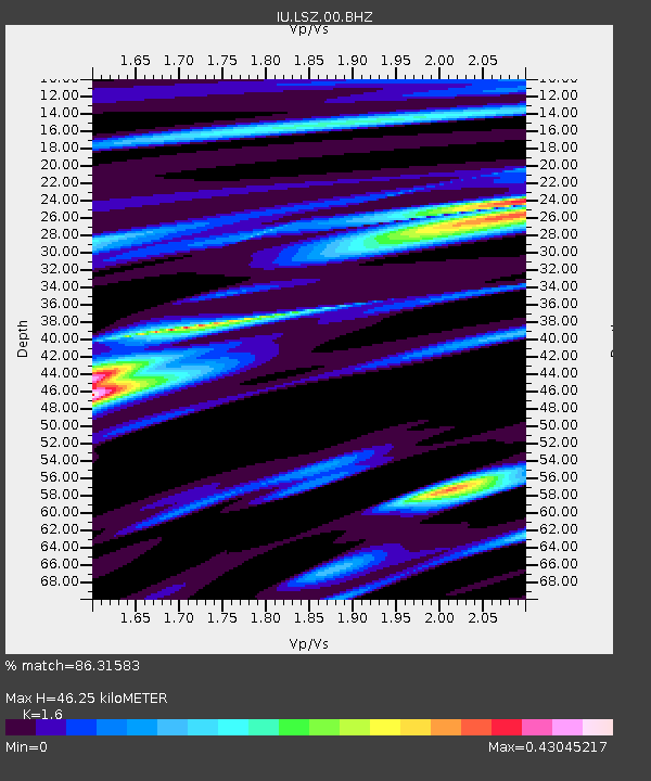
| Estimated Moho Depth: |
46.25 km |
| Estimated Crust Vp/Vs: |
1.60 |
| Assumed Crust Vp: |
6.642 km/s |
| Estimated Crust Vs: |
4.151 km/s |
| Estimated Crust Poisson's Ratio: |
0.18 |
|
| Radial Match: |
86.31583 % |
| Radial Bump: |
322 |
| Transverse Match: |
64.339645 % |
| Transverse Bump: |
358 |
| SOD ConfigId: |
2429771 |
| Insert Time: |
2017-12-01 22:35:39.757 +0000 |
| GWidth: |
2.5 |
| Max Bumps: |
400 |
| Tol: |
0.001 |
|
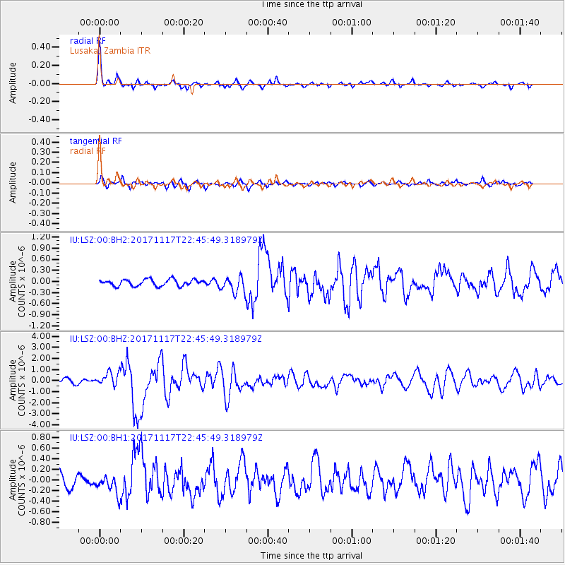
Signal To Noise
| Channel | StoN | STA | LTA |
| IU:LSZ:00:BHZ:20171117T22:45:49.318979Z | 3.1420004 | 6.318493E-7 | 2.0109776E-7 |
| IU:LSZ:00:BH1:20171117T22:45:49.318979Z | 1.1126534 | 1.8711755E-7 | 1.6817236E-7 |
| IU:LSZ:00:BH2:20171117T22:45:49.318979Z | 2.5568225 | 2.2157195E-7 | 8.665911E-8 |
| Arrivals |
| Ps | 4.3 SECOND |
| PpPs | 17 SECOND |
| PsPs/PpSs | 22 SECOND |


