You are here: Home > Network List > TX - Texas Seismological Network Stations List
> Station SN07 Snyder 07 > Earthquake Result Viewer
SN07 Snyder 07 - Earthquake Result Viewer
| Earthquake location: |
Near East Coast Of Honshu, Japan |
| Earthquake latitude/longitude: |
38.1/141.8 |
| Earthquake time(UTC): |
2021/05/01 (121) 01:27:30 GMT |
| Earthquake Depth: |
56 km |
| Earthquake Magnitude: |
6.6 Mi |
| Earthquake Catalog/Contributor: |
NEIC PDE/at |
|
| Network: |
TX Texas Seismological Network |
| Station: |
SN07 Snyder 07 |
| Lat/Lon: |
33.09 N/100.89 W |
| Elevation: |
620 m |
|
| Distance: |
88.3 deg |
| Az: |
48.267 deg |
| Baz: |
315.466 deg |
| Ray Param: |
0.042608734 |
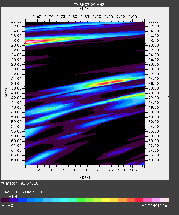
| Estimated Moho Depth: |
18.5 km |
| Estimated Crust Vp/Vs: |
1.60 |
| Assumed Crust Vp: |
6.426 km/s |
| Estimated Crust Vs: |
4.016 km/s |
| Estimated Crust Poisson's Ratio: |
0.18 |
|
| Radial Match: |
92.57258 % |
| Radial Bump: |
301 |
| Transverse Match: |
72.74491 % |
| Transverse Bump: |
366 |
| SOD ConfigId: |
24334971 |
| Insert Time: |
2021-05-15 02:02:00.561 +0000 |
| GWidth: |
2.5 |
| Max Bumps: |
400 |
| Tol: |
0.001 |
|

Signal To Noise
| Channel | StoN | STA | LTA |
| TX:SN07:00:HHZ:20210501T01:39:44.150024Z | 12.216468 | 1.2746964E-6 | 1.0434247E-7 |
| TX:SN07:00:HH1:20210501T01:39:44.150024Z | 3.2117107 | 2.8632238E-7 | 8.914949E-8 |
| TX:SN07:00:HH2:20210501T01:39:44.150024Z | 3.6577733 | 3.5627409E-7 | 9.74019E-8 |
| Arrivals |
| Ps | 1.8 SECOND |
| PpPs | 7.3 SECOND |
| PsPs/PpSs | 9.1 SECOND |


