You are here: Home > Network List > TX - Texas Seismological Network Stations List
> Station PB32 CR 111 > Earthquake Result Viewer
PB32 CR 111 - Earthquake Result Viewer
| Earthquake location: |
Near East Coast Of Honshu, Japan |
| Earthquake latitude/longitude: |
38.1/141.8 |
| Earthquake time(UTC): |
2021/05/01 (121) 01:27:30 GMT |
| Earthquake Depth: |
56 km |
| Earthquake Magnitude: |
6.6 Mi |
| Earthquake Catalog/Contributor: |
NEIC PDE/at |
|
| Network: |
TX Texas Seismological Network |
| Station: |
PB32 CR 111 |
| Lat/Lon: |
31.10 N/103.37 W |
| Elevation: |
861 m |
|
| Distance: |
88.2 deg |
| Az: |
51.158 deg |
| Baz: |
314.243 deg |
| Ray Param: |
0.04267992 |
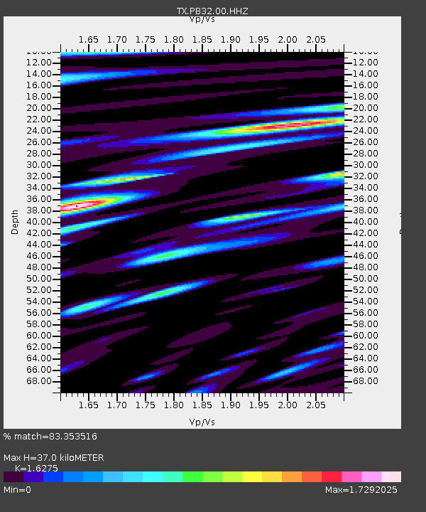
| Estimated Moho Depth: |
37.0 km |
| Estimated Crust Vp/Vs: |
1.63 |
| Assumed Crust Vp: |
6.121 km/s |
| Estimated Crust Vs: |
3.761 km/s |
| Estimated Crust Poisson's Ratio: |
0.20 |
|
| Radial Match: |
83.353516 % |
| Radial Bump: |
400 |
| Transverse Match: |
68.84523 % |
| Transverse Bump: |
400 |
| SOD ConfigId: |
24334971 |
| Insert Time: |
2021-05-15 02:02:15.589 +0000 |
| GWidth: |
2.5 |
| Max Bumps: |
400 |
| Tol: |
0.001 |
|

Signal To Noise
| Channel | StoN | STA | LTA |
| TX:PB32:00:HHZ:20210501T01:39:43.700012Z | 7.82871 | 1.04805615E-7 | 1.3387342E-8 |
| TX:PB32:00:HH1:20210501T01:39:43.700012Z | 2.3275023 | 3.6445563E-8 | 1.565866E-8 |
| TX:PB32:00:HH2:20210501T01:39:43.700012Z | 1.9884154 | 3.6662094E-8 | 1.8437845E-8 |
| Arrivals |
| Ps | 3.9 SECOND |
| PpPs | 16 SECOND |
| PsPs/PpSs | 19 SECOND |


