You are here: Home > Network List > US - United States National Seismic Network Stations List
> Station AGMN Agassiz National Wildlife Refuge, Minnesota, USA > Earthquake Result Viewer
AGMN Agassiz National Wildlife Refuge, Minnesota, USA - Earthquake Result Viewer

| Earthquake location: |
Near East Coast Of Honshu, Japan |
| Earthquake latitude/longitude: |
38.1/141.8 |
| Earthquake time(UTC): |
2021/05/01 (121) 01:27:30 GMT |
| Earthquake Depth: |
56 km |
| Earthquake Magnitude: |
6.6 Mi |
| Earthquake Catalog/Contributor: |
NEIC PDE/at |
|
| Network: |
US United States National Seismic Network |
| Station: |
AGMN Agassiz National Wildlife Refuge, Minnesota, USA |
| Lat/Lon: |
48.30 N/95.86 W |
| Elevation: |
351 m |
|
| Distance: |
79.9 deg |
| Az: |
34.966 deg |
| Baz: |
317.382 deg |
| Ray Param: |
0.04855612 |
| Estimated Moho Depth: |
49.0 km |
| Estimated Crust Vp/Vs: |
1.69 |
| Assumed Crust Vp: |
6.419 km/s |
| Estimated Crust Vs: |
3.81 km/s |
| Estimated Crust Poisson's Ratio: |
0.23 |
|
| Radial Match: |
93.51434 % |
| Radial Bump: |
400 |
| Transverse Match: |
75.25034 % |
| Transverse Bump: |
400 |
| SOD ConfigId: |
24334971 |
| Insert Time: |
2021-05-15 02:03:08.914 +0000 |
| GWidth: |
2.5 |
| Max Bumps: |
400 |
| Tol: |
0.001 |
|
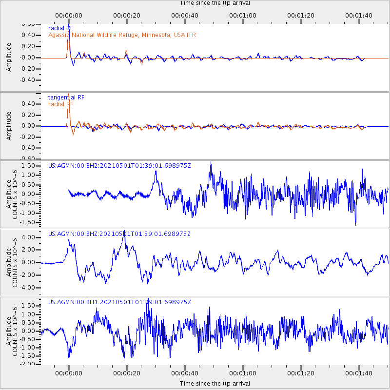
Signal To Noise
| Channel | StoN | STA | LTA |
| US:AGMN:00:BHZ:20210501T01:39:01.698975Z | 19.338781 | 2.3104976E-6 | 1.1947482E-7 |
| US:AGMN:00:BH1:20210501T01:39:01.698975Z | 6.1958985 | 7.535296E-7 | 1.2161749E-7 |
| US:AGMN:00:BH2:20210501T01:39:01.698975Z | 5.126127 | 5.709041E-7 | 1.1137143E-7 |
| Arrivals |
| Ps | 5.4 SECOND |
| PpPs | 20 SECOND |
| PsPs/PpSs | 25 SECOND |


