You are here: Home > Network List > UU - University of Utah Regional Network Stations List
> Station FOR2 Blundell East, UT, USA > Earthquake Result Viewer
FOR2 Blundell East, UT, USA - Earthquake Result Viewer
| Earthquake location: |
Near East Coast Of Honshu, Japan |
| Earthquake latitude/longitude: |
38.1/141.8 |
| Earthquake time(UTC): |
2021/05/01 (121) 01:27:30 GMT |
| Earthquake Depth: |
56 km |
| Earthquake Magnitude: |
6.6 Mi |
| Earthquake Catalog/Contributor: |
NEIC PDE/at |
|
| Network: |
UU University of Utah Regional Network |
| Station: |
FOR2 Blundell East, UT, USA |
| Lat/Lon: |
38.49 N/112.87 W |
| Elevation: |
1760 m |
|
| Distance: |
77.5 deg |
| Az: |
50.832 deg |
| Baz: |
308.785 deg |
| Ray Param: |
0.050214596 |
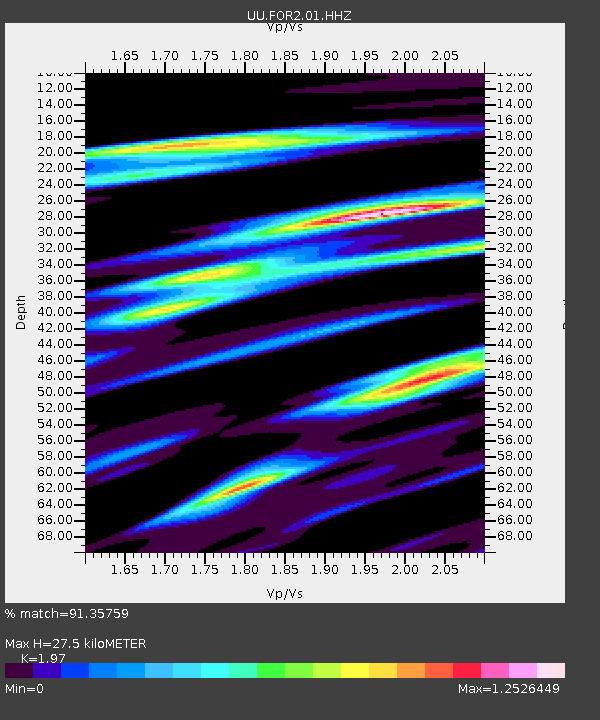
| Estimated Moho Depth: |
27.5 km |
| Estimated Crust Vp/Vs: |
1.97 |
| Assumed Crust Vp: |
6.276 km/s |
| Estimated Crust Vs: |
3.186 km/s |
| Estimated Crust Poisson's Ratio: |
0.33 |
|
| Radial Match: |
91.35759 % |
| Radial Bump: |
400 |
| Transverse Match: |
77.49916 % |
| Transverse Bump: |
400 |
| SOD ConfigId: |
24334971 |
| Insert Time: |
2021-05-15 02:04:33.525 +0000 |
| GWidth: |
2.5 |
| Max Bumps: |
400 |
| Tol: |
0.001 |
|

Signal To Noise
| Channel | StoN | STA | LTA |
| UU:FOR2:01:HHZ:20210501T01:38:48.359985Z | 8.756175 | 3.673774E-8 | 4.1956385E-9 |
| UU:FOR2:01:HHN:20210501T01:38:48.359985Z | 2.4884603 | 9.794363E-9 | 3.935913E-9 |
| UU:FOR2:01:HHE:20210501T01:38:48.359985Z | 3.8976264 | 1.4606263E-8 | 3.747476E-9 |
| Arrivals |
| Ps | 4.4 SECOND |
| PpPs | 13 SECOND |
| PsPs/PpSs | 17 SECOND |


