You are here: Home > Network List > UU - University of Utah Regional Network Stations List
> Station SPU South Promontory Point, UT, USA > Earthquake Result Viewer
SPU South Promontory Point, UT, USA - Earthquake Result Viewer
| Earthquake location: |
Near East Coast Of Honshu, Japan |
| Earthquake latitude/longitude: |
38.1/141.8 |
| Earthquake time(UTC): |
2021/05/01 (121) 01:27:30 GMT |
| Earthquake Depth: |
56 km |
| Earthquake Magnitude: |
6.6 Mi |
| Earthquake Catalog/Contributor: |
NEIC PDE/at |
|
| Network: |
UU University of Utah Regional Network |
| Station: |
SPU South Promontory Point, UT, USA |
| Lat/Lon: |
41.31 N/112.45 W |
| Elevation: |
2086 m |
|
| Distance: |
76.0 deg |
| Az: |
48.368 deg |
| Baz: |
308.489 deg |
| Ray Param: |
0.051213555 |
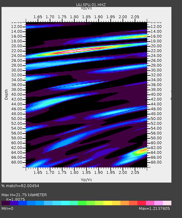
| Estimated Moho Depth: |
21.75 km |
| Estimated Crust Vp/Vs: |
1.81 |
| Assumed Crust Vp: |
6.276 km/s |
| Estimated Crust Vs: |
3.472 km/s |
| Estimated Crust Poisson's Ratio: |
0.28 |
|
| Radial Match: |
92.00454 % |
| Radial Bump: |
382 |
| Transverse Match: |
78.332985 % |
| Transverse Bump: |
400 |
| SOD ConfigId: |
24334971 |
| Insert Time: |
2021-05-15 02:04:52.788 +0000 |
| GWidth: |
2.5 |
| Max Bumps: |
400 |
| Tol: |
0.001 |
|

Signal To Noise
| Channel | StoN | STA | LTA |
| UU:SPU:01:HHZ:20210501T01:38:39.929993Z | 10.50301 | 3.5109636E-8 | 3.342817E-9 |
| UU:SPU:01:HHN:20210501T01:38:39.929993Z | 4.945313 | 1.3982139E-8 | 2.8273517E-9 |
| UU:SPU:01:HHE:20210501T01:38:39.929993Z | 3.6811647 | 1.3287363E-8 | 3.609554E-9 |
| Arrivals |
| Ps | 2.9 SECOND |
| PpPs | 9.4 SECOND |
| PsPs/PpSs | 12 SECOND |


