You are here: Home > Network List > UW - Pacific Northwest Regional Seismic Network Stations List
> Station RATT Rattlesnake Lake, King County, WA > Earthquake Result Viewer
RATT Rattlesnake Lake, King County, WA - Earthquake Result Viewer
| Earthquake location: |
Near East Coast Of Honshu, Japan |
| Earthquake latitude/longitude: |
38.1/141.8 |
| Earthquake time(UTC): |
2021/05/01 (121) 01:27:30 GMT |
| Earthquake Depth: |
56 km |
| Earthquake Magnitude: |
6.6 Mi |
| Earthquake Catalog/Contributor: |
NEIC PDE/at |
|
| Network: |
UW Pacific Northwest Regional Seismic Network |
| Station: |
RATT Rattlesnake Lake, King County, WA |
| Lat/Lon: |
47.43 N/121.80 W |
| Elevation: |
442 m |
|
| Distance: |
67.0 deg |
| Az: |
47.163 deg |
| Baz: |
301.57 deg |
| Ray Param: |
0.057147823 |
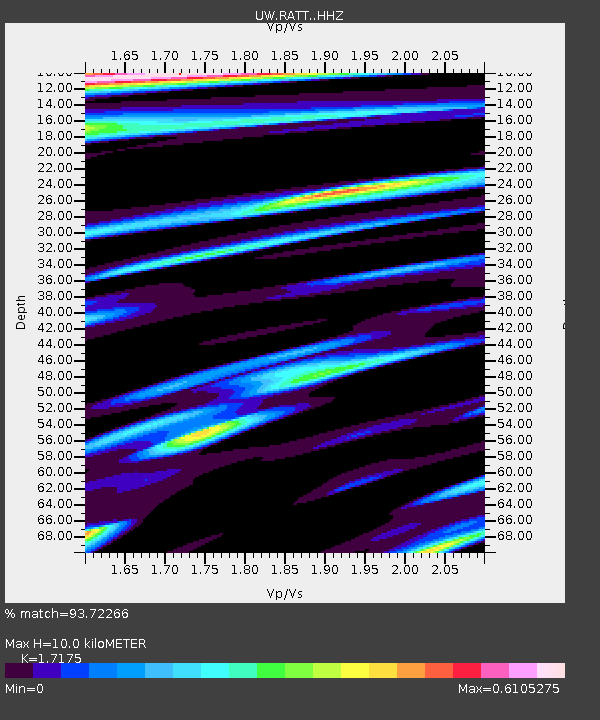
| Estimated Moho Depth: |
10.0 km |
| Estimated Crust Vp/Vs: |
1.72 |
| Assumed Crust Vp: |
6.597 km/s |
| Estimated Crust Vs: |
3.841 km/s |
| Estimated Crust Poisson's Ratio: |
0.24 |
|
| Radial Match: |
93.72266 % |
| Radial Bump: |
379 |
| Transverse Match: |
85.10417 % |
| Transverse Bump: |
400 |
| SOD ConfigId: |
24334971 |
| Insert Time: |
2021-05-15 02:06:15.314 +0000 |
| GWidth: |
2.5 |
| Max Bumps: |
400 |
| Tol: |
0.001 |
|

Signal To Noise
| Channel | StoN | STA | LTA |
| UW:RATT: :HHZ:20210501T01:37:45.919983Z | 13.511145 | 1.6566097E-6 | 1.226106E-7 |
| UW:RATT: :HHN:20210501T01:37:45.919983Z | 1.967175 | 2.2869072E-7 | 1.1625337E-7 |
| UW:RATT: :HHE:20210501T01:37:45.919983Z | 6.265641 | 6.431277E-7 | 1.02643554E-7 |
| Arrivals |
| Ps | 1.1 SECOND |
| PpPs | 3.9 SECOND |
| PsPs/PpSs | 5.1 SECOND |


