You are here: Home > Network List > HW - Hanford Washington Seismic Network Stations List
> Station DDRF Dider Farm, Eltopia, WA, USA > Earthquake Result Viewer
DDRF Dider Farm, Eltopia, WA, USA - Earthquake Result Viewer
| Earthquake location: |
Azores Islands Region |
| Earthquake latitude/longitude: |
36.2/-33.9 |
| Earthquake time(UTC): |
2009/11/04 (308) 18:41:44 GMT |
| Earthquake Depth: |
10 km |
| Earthquake Magnitude: |
5.7 MB, 5.6 MS, 5.9 MW, 5.8 MW |
| Earthquake Catalog/Contributor: |
WHDF/NEIC |
|
| Network: |
HW Hanford Washington Seismic Network |
| Station: |
DDRF Dider Farm, Eltopia, WA, USA |
| Lat/Lon: |
46.49 N/119.06 W |
| Elevation: |
233 m |
|
| Distance: |
61.9 deg |
| Az: |
308.674 deg |
| Baz: |
66.14 deg |
| Ray Param: |
0.06060353 |
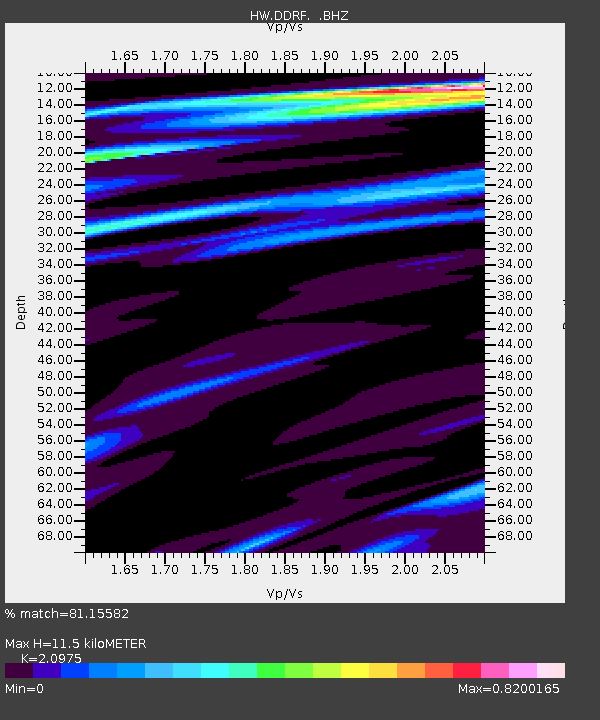
| Estimated Moho Depth: |
11.5 km |
| Estimated Crust Vp/Vs: |
2.10 |
| Assumed Crust Vp: |
6.419 km/s |
| Estimated Crust Vs: |
3.06 km/s |
| Estimated Crust Poisson's Ratio: |
0.35 |
|
| Radial Match: |
81.15582 % |
| Radial Bump: |
382 |
| Transverse Match: |
62.171112 % |
| Transverse Bump: |
333 |
| SOD ConfigId: |
2622 |
| Insert Time: |
2010-03-09 07:58:10.164 +0000 |
| GWidth: |
2.5 |
| Max Bumps: |
400 |
| Tol: |
0.001 |
|

Signal To Noise
| Channel | StoN | STA | LTA |
| HW:DDRF: :BHZ:20091104T18:51:32.550002Z | 10.039961 | 1.6558811E-6 | 1.6492902E-7 |
| HW:DDRF: :BHN:20091104T18:51:32.550002Z | 2.421588 | 3.1302895E-7 | 1.2926598E-7 |
| HW:DDRF: :BHE:20091104T18:51:32.550002Z | 6.0394864 | 6.159938E-7 | 1.0199441E-7 |
| Arrivals |
| Ps | 2.0 SECOND |
| PpPs | 5.3 SECOND |
| PsPs/PpSs | 7.4 SECOND |


