You are here: Home > Network List > HW - Hanford Washington Seismic Network Stations List
> Station DDRF Dider Farm, Eltopia, WA, USA > Earthquake Result Viewer
DDRF Dider Farm, Eltopia, WA, USA - Earthquake Result Viewer
| Earthquake location: |
Southern Peru |
| Earthquake latitude/longitude: |
-15.0/-70.4 |
| Earthquake time(UTC): |
2009/07/12 (193) 06:12:47 GMT |
| Earthquake Depth: |
199 km |
| Earthquake Magnitude: |
5.7 MB, 6.1 MW, 6.1 MW |
| Earthquake Catalog/Contributor: |
WHDF/NEIC |
|
| Network: |
HW Hanford Washington Seismic Network |
| Station: |
DDRF Dider Farm, Eltopia, WA, USA |
| Lat/Lon: |
46.49 N/119.06 W |
| Elevation: |
233 m |
|
| Distance: |
75.2 deg |
| Az: |
327.584 deg |
| Baz: |
131.439 deg |
| Ray Param: |
0.05128136 |
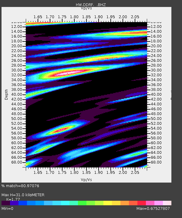
| Estimated Moho Depth: |
31.0 km |
| Estimated Crust Vp/Vs: |
1.77 |
| Assumed Crust Vp: |
6.419 km/s |
| Estimated Crust Vs: |
3.627 km/s |
| Estimated Crust Poisson's Ratio: |
0.27 |
|
| Radial Match: |
80.97076 % |
| Radial Bump: |
400 |
| Transverse Match: |
72.45231 % |
| Transverse Bump: |
400 |
| SOD ConfigId: |
2648 |
| Insert Time: |
2010-03-09 07:58:26.215 +0000 |
| GWidth: |
2.5 |
| Max Bumps: |
400 |
| Tol: |
0.001 |
|

Signal To Noise
| Channel | StoN | STA | LTA |
| HW:DDRF: :BHZ:20090712T06:23:37.074019Z | 4.6046934 | 3.7822855E-7 | 8.213979E-8 |
| HW:DDRF: :BHN:20090712T06:23:37.074019Z | 2.6179047 | 9.053467E-8 | 3.458288E-8 |
| HW:DDRF: :BHE:20090712T06:23:37.074019Z | 2.4151938 | 1.4270029E-7 | 5.9084403E-8 |
| Arrivals |
| Ps | 3.8 SECOND |
| PpPs | 13 SECOND |
| PsPs/PpSs | 17 SECOND |


