You are here: Home > Network List > IU - Global Seismograph Network (GSN - IRIS/USGS) Stations List
> Station POHA Pohakuloa, Hawaii, USA > Earthquake Result Viewer
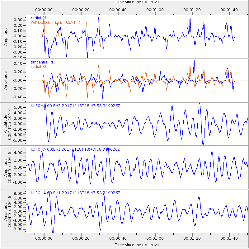
POHA Pohakuloa, Hawaii, USA - Earthquake Result Viewer
*The percent match for this event was below the threshold and hence no stack was calculated.
| Earthquake location: |
Halmahera, Indonesia |
| Earthquake latitude/longitude: |
2.4/128.1 |
| Earthquake time(UTC): |
2017/11/18 (322) 18:36:41 GMT |
| Earthquake Depth: |
17 km |
| Earthquake Magnitude: |
5.4 Mww |
| Earthquake Catalog/Contributor: |
NEIC PDE/us |
|
| Network: |
IU Global Seismograph Network (GSN - IRIS/USGS) |
| Station: |
POHA Pohakuloa, Hawaii, USA |
| Lat/Lon: |
19.76 N/155.53 W |
| Elevation: |
1990 m |
|
| Distance: |
76.3 deg |
| Az: |
70.363 deg |
| Baz: |
267.615 deg |
| Ray Param: |
$rayparam |
*The percent match for this event was below the threshold and hence was not used in the summary stack. |
|
| Radial Match: |
42.46569 % |
| Radial Bump: |
400 |
| Transverse Match: |
38.99752 % |
| Transverse Bump: |
303 |
| SOD ConfigId: |
2429771 |
| Insert Time: |
2017-12-02 18:37:28.498 +0000 |
| GWidth: |
2.5 |
| Max Bumps: |
400 |
| Tol: |
0.001 |
|
Signal To Noise
| Channel | StoN | STA | LTA |
| IU:POHA:00:BHZ:20171118T18:47:58.319026Z | 1.1663779 | 2.0441682E-6 | 1.7525779E-6 |
| IU:POHA:00:BH1:20171118T18:47:58.319026Z | 3.1386163 | 5.8349533E-6 | 1.8590846E-6 |
| IU:POHA:00:BH2:20171118T18:47:58.319026Z | 0.25336766 | 6.7369035E-7 | 2.6589437E-6 |
| Arrivals |
| Ps | |
| PpPs | |
| PsPs/PpSs | |


