You are here: Home > Network List > CH - Switzerland Seismological Network Stations List
> Station FUORN CH.FUORN > Earthquake Result Viewer
FUORN CH.FUORN - Earthquake Result Viewer
| Earthquake location: |
Near S. Coast Of Honshu, Japan |
| Earthquake latitude/longitude: |
35.5/140.0 |
| Earthquake time(UTC): |
2005/07/23 (204) 07:34:56 GMT |
| Earthquake Depth: |
61 km |
| Earthquake Magnitude: |
6.1 MB, 6.0 MW, 6.0 MW |
| Earthquake Catalog/Contributor: |
WHDF/NEIC |
|
| Network: |
CH Switzerland Seismological Network |
| Station: |
FUORN CH.FUORN |
| Lat/Lon: |
46.62 N/10.26 E |
| Elevation: |
2333 m |
|
| Distance: |
86.6 deg |
| Az: |
327.919 deg |
| Baz: |
38.958 deg |
| Ray Param: |
0.04382721 |
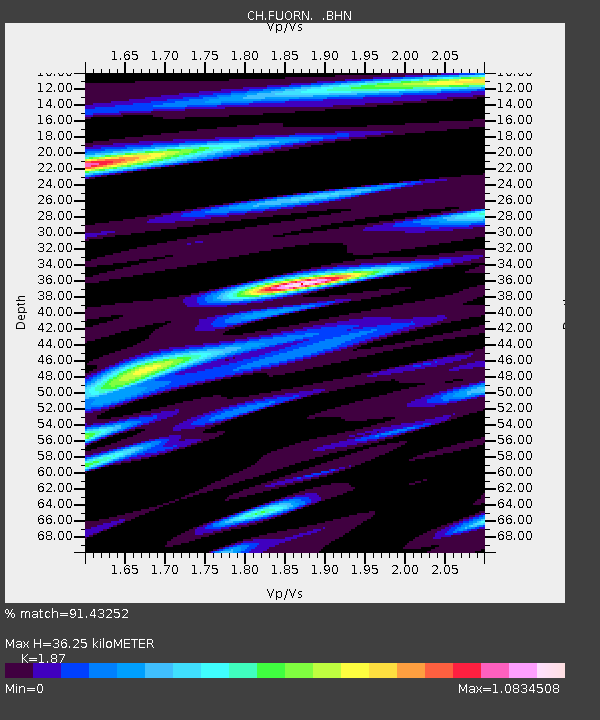
| Estimated Moho Depth: |
36.25 km |
| Estimated Crust Vp/Vs: |
1.87 |
| Assumed Crust Vp: |
6.35 km/s |
| Estimated Crust Vs: |
3.396 km/s |
| Estimated Crust Poisson's Ratio: |
0.30 |
|
| Radial Match: |
91.43252 % |
| Radial Bump: |
400 |
| Transverse Match: |
90.85305 % |
| Transverse Bump: |
400 |
| SOD ConfigId: |
2475 |
| Insert Time: |
2010-02-25 19:16:58.984 +0000 |
| GWidth: |
2.5 |
| Max Bumps: |
400 |
| Tol: |
0.001 |
|

Signal To Noise
| Channel | StoN | STA | LTA |
| CH:FUORN: :BHN:20050723T07:47:02.251018Z | 10.04268 | 4.2247132E-7 | 4.206759E-8 |
| CH:FUORN: :BHE:20050723T07:47:02.251018Z | 5.5389853 | 3.1569598E-7 | 5.6995276E-8 |
| CH:FUORN: :BHZ:20050723T07:47:02.251018Z | 30.437557 | 1.7035679E-6 | 5.5969274E-8 |
| Arrivals |
| Ps | 5.1 SECOND |
| PpPs | 16 SECOND |
| PsPs/PpSs | 21 SECOND |


