You are here: Home > Network List > IU - Global Seismograph Network (GSN - IRIS/USGS) Stations List
> Station POHA Pohakuloa, Hawaii, USA > Earthquake Result Viewer
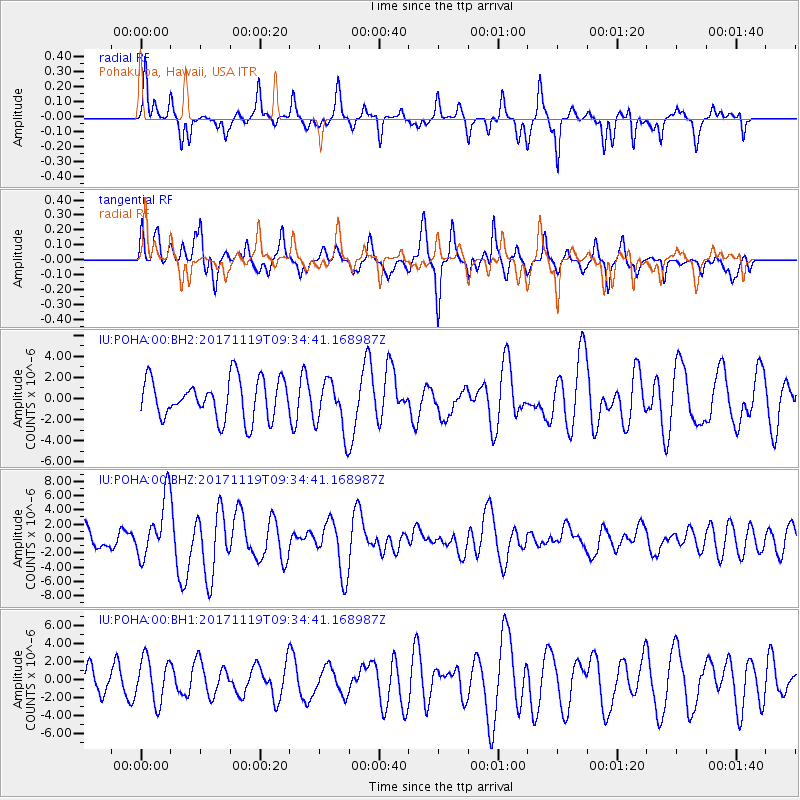
POHA Pohakuloa, Hawaii, USA - Earthquake Result Viewer
*The percent match for this event was below the threshold and hence no stack was calculated.
| Earthquake location: |
Loyalty Islands |
| Earthquake latitude/longitude: |
-21.7/168.7 |
| Earthquake time(UTC): |
2017/11/19 (323) 09:25:47 GMT |
| Earthquake Depth: |
4.0 km |
| Earthquake Magnitude: |
6.3 mww |
| Earthquake Catalog/Contributor: |
NEIC PDE/us |
|
| Network: |
IU Global Seismograph Network (GSN - IRIS/USGS) |
| Station: |
POHA Pohakuloa, Hawaii, USA |
| Lat/Lon: |
19.76 N/155.53 W |
| Elevation: |
1990 m |
|
| Distance: |
54.0 deg |
| Az: |
42.874 deg |
| Baz: |
222.224 deg |
| Ray Param: |
$rayparam |
*The percent match for this event was below the threshold and hence was not used in the summary stack. |
|
| Radial Match: |
59.674522 % |
| Radial Bump: |
256 |
| Transverse Match: |
63.745255 % |
| Transverse Bump: |
352 |
| SOD ConfigId: |
2429771 |
| Insert Time: |
2017-12-03 09:27:06.864 +0000 |
| GWidth: |
2.5 |
| Max Bumps: |
400 |
| Tol: |
0.001 |
|
Signal To Noise
| Channel | StoN | STA | LTA |
| IU:POHA:00:BHZ:20171119T09:34:41.168987Z | 2.144356 | 4.1943354E-6 | 1.9559884E-6 |
| IU:POHA:00:BH1:20171119T09:34:41.168987Z | 1.3999326 | 2.4346325E-6 | 1.739107E-6 |
| IU:POHA:00:BH2:20171119T09:34:41.168987Z | 1.3149232 | 2.4690912E-6 | 1.8777457E-6 |
| Arrivals |
| Ps | |
| PpPs | |
| PsPs/PpSs | |


