You are here: Home > Network List > IU - Global Seismograph Network (GSN - IRIS/USGS) Stations List
> Station XMAS Kiritimati Island, Republic of Kiribati > Earthquake Result Viewer
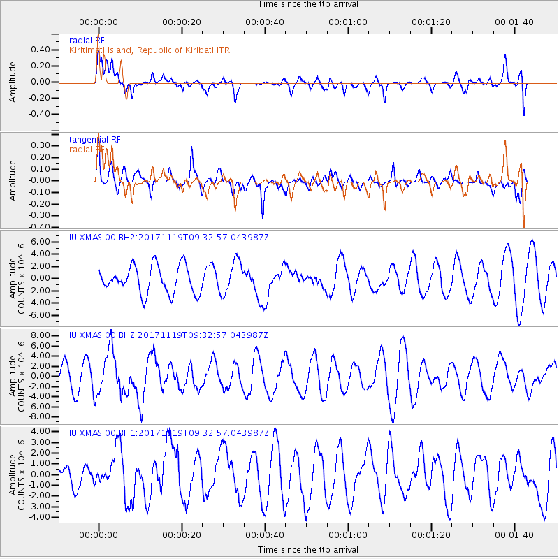
XMAS Kiritimati Island, Republic of Kiribati - Earthquake Result Viewer
*The percent match for this event was below the threshold and hence no stack was calculated.
| Earthquake location: |
Loyalty Islands |
| Earthquake latitude/longitude: |
-21.7/168.7 |
| Earthquake time(UTC): |
2017/11/19 (323) 09:25:47 GMT |
| Earthquake Depth: |
4.0 km |
| Earthquake Magnitude: |
6.3 mww |
| Earthquake Catalog/Contributor: |
NEIC PDE/us |
|
| Network: |
IU Global Seismograph Network (GSN - IRIS/USGS) |
| Station: |
XMAS Kiritimati Island, Republic of Kiribati |
| Lat/Lon: |
2.04 N/157.45 W |
| Elevation: |
20 m |
|
| Distance: |
40.6 deg |
| Az: |
58.78 deg |
| Baz: |
232.755 deg |
| Ray Param: |
$rayparam |
*The percent match for this event was below the threshold and hence was not used in the summary stack. |
|
| Radial Match: |
68.35642 % |
| Radial Bump: |
400 |
| Transverse Match: |
64.87323 % |
| Transverse Bump: |
400 |
| SOD ConfigId: |
2429771 |
| Insert Time: |
2017-12-03 09:27:17.471 +0000 |
| GWidth: |
2.5 |
| Max Bumps: |
400 |
| Tol: |
0.001 |
|
Signal To Noise
| Channel | StoN | STA | LTA |
| IU:XMAS:00:BHZ:20171119T09:32:57.043987Z | 1.9810667 | 4.5021056E-6 | 2.2725665E-6 |
| IU:XMAS:00:BH1:20171119T09:32:57.043987Z | 1.2218281 | 1.6127442E-6 | 1.3199436E-6 |
| IU:XMAS:00:BH2:20171119T09:32:57.043987Z | 1.222767 | 2.69897E-6 | 2.2072643E-6 |
| Arrivals |
| Ps | |
| PpPs | |
| PsPs/PpSs | |


