You are here: Home > Network List > WY - Yellowstone Wyoming Seismic Network Stations List
> Station YHH Holmes Hill, YNP, WY, USA > Earthquake Result Viewer
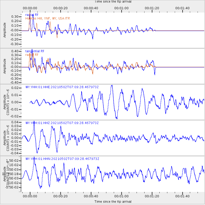
YHH Holmes Hill, YNP, WY, USA - Earthquake Result Viewer
*The percent match for this event was below the threshold and hence no stack was calculated.
| Earthquake location: |
Near Coast Of Central Chile |
| Earthquake latitude/longitude: |
-30.1/-71.6 |
| Earthquake time(UTC): |
2021/05/02 (122) 06:57:38 GMT |
| Earthquake Depth: |
31 km |
| Earthquake Magnitude: |
5.8 Mww |
| Earthquake Catalog/Contributor: |
NEIC PDE/us |
|
| Network: |
WY Yellowstone Wyoming Seismic Network |
| Station: |
YHH Holmes Hill, YNP, WY, USA |
| Lat/Lon: |
44.79 N/110.85 W |
| Elevation: |
2717 m |
|
| Distance: |
82.7 deg |
| Az: |
332.973 deg |
| Baz: |
146.441 deg |
| Ray Param: |
$rayparam |
*The percent match for this event was below the threshold and hence was not used in the summary stack. |
|
| Radial Match: |
72.907776 % |
| Radial Bump: |
400 |
| Transverse Match: |
73.28494 % |
| Transverse Bump: |
400 |
| SOD ConfigId: |
24828478 |
| Insert Time: |
2021-05-16 07:38:17.169 +0000 |
| GWidth: |
2.5 |
| Max Bumps: |
400 |
| Tol: |
0.001 |
|
Signal To Noise
| Channel | StoN | STA | LTA |
| WY:YHH:01:HHZ:20210502T07:09:28.467973Z | 3.2112398 | 1.9978199E-8 | 6.2213346E-9 |
| WY:YHH:01:HHN:20210502T07:09:28.467973Z | 1.3892163 | 8.573316E-9 | 6.171333E-9 |
| WY:YHH:01:HHE:20210502T07:09:28.467973Z | 4.192916 | 8.504965E-9 | 2.0284128E-9 |
| Arrivals |
| Ps | |
| PpPs | |
| PsPs/PpSs | |


