You are here: Home > Network List > AV - Alaska Volcano Observatory Stations List
> Station MAPS Pakushin Southeast, Makushin Volcano, Alaska > Earthquake Result Viewer
MAPS Pakushin Southeast, Makushin Volcano, Alaska - Earthquake Result Viewer
| Earthquake location: |
Southern Sumatra, Indonesia |
| Earthquake latitude/longitude: |
-2.3/99.8 |
| Earthquake time(UTC): |
2021/05/02 (122) 17:46:41 GMT |
| Earthquake Depth: |
21 km |
| Earthquake Magnitude: |
5.5 mww |
| Earthquake Catalog/Contributor: |
NEIC PDE/us |
|
| Network: |
AV Alaska Volcano Observatory |
| Station: |
MAPS Pakushin Southeast, Makushin Volcano, Alaska |
| Lat/Lon: |
53.81 N/166.94 W |
| Elevation: |
333 m |
|
| Distance: |
93.8 deg |
| Az: |
36.399 deg |
| Baz: |
271.26 deg |
| Ray Param: |
0.041193772 |
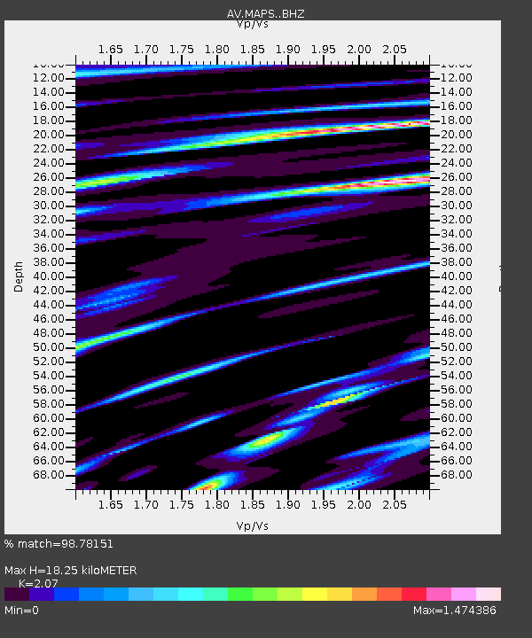
| Estimated Moho Depth: |
18.25 km |
| Estimated Crust Vp/Vs: |
2.07 |
| Assumed Crust Vp: |
3.943 km/s |
| Estimated Crust Vs: |
1.905 km/s |
| Estimated Crust Poisson's Ratio: |
0.35 |
|
| Radial Match: |
98.78151 % |
| Radial Bump: |
218 |
| Transverse Match: |
65.83104 % |
| Transverse Bump: |
400 |
| SOD ConfigId: |
24844331 |
| Insert Time: |
2021-05-16 17:50:46.874 +0000 |
| GWidth: |
2.5 |
| Max Bumps: |
400 |
| Tol: |
0.001 |
|

Signal To Noise
| Channel | StoN | STA | LTA |
| AV:MAPS: :BHZ:20210502T17:59:24.87902Z | 0.71777076 | 1.2381327E-6 | 1.7249695E-6 |
| AV:MAPS: :BHN:20210502T17:59:24.87902Z | 1.5143634 | 6.984586E-7 | 4.6122258E-7 |
| AV:MAPS: :BHE:20210502T17:59:24.87902Z | 0.7074571 | 4.9446785E-6 | 6.989368E-6 |
| Arrivals |
| Ps | 5.0 SECOND |
| PpPs | 14 SECOND |
| PsPs/PpSs | 19 SECOND |


