You are here: Home > Network List > IO - International OGS Network Stations List
> Station EVN EvK2CNR Pyramid Laboratory - Mount Everest > Earthquake Result Viewer
EVN EvK2CNR Pyramid Laboratory - Mount Everest - Earthquake Result Viewer
| Earthquake location: |
Southern Sumatra, Indonesia |
| Earthquake latitude/longitude: |
-2.3/99.8 |
| Earthquake time(UTC): |
2021/05/02 (122) 17:46:41 GMT |
| Earthquake Depth: |
21 km |
| Earthquake Magnitude: |
5.5 mww |
| Earthquake Catalog/Contributor: |
NEIC PDE/us |
|
| Network: |
IO International OGS Network |
| Station: |
EVN EvK2CNR Pyramid Laboratory - Mount Everest |
| Lat/Lon: |
27.96 N/86.81 E |
| Elevation: |
5010 m |
|
| Distance: |
32.6 deg |
| Az: |
338.304 deg |
| Baz: |
155.318 deg |
| Ray Param: |
0.07858042 |
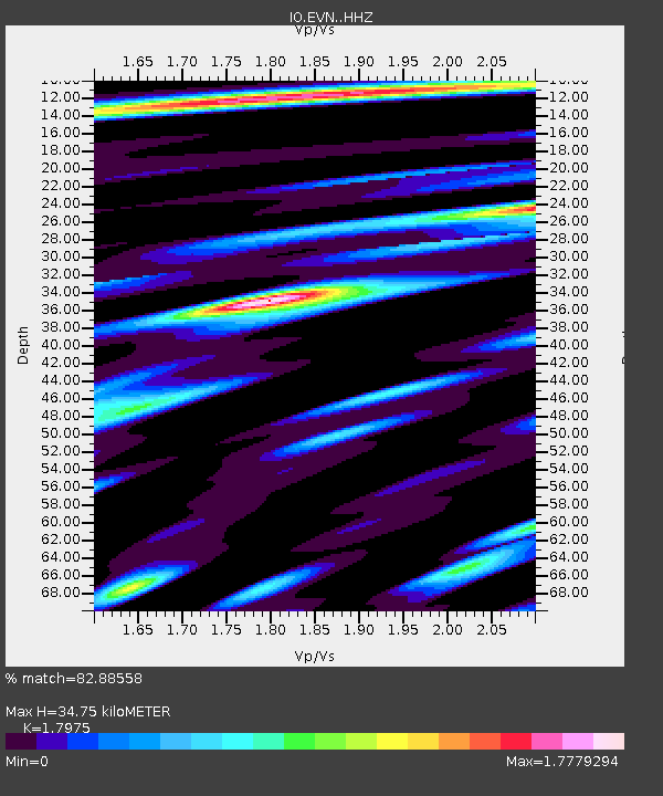
| Estimated Moho Depth: |
34.75 km |
| Estimated Crust Vp/Vs: |
1.80 |
| Assumed Crust Vp: |
6.236 km/s |
| Estimated Crust Vs: |
3.469 km/s |
| Estimated Crust Poisson's Ratio: |
0.28 |
|
| Radial Match: |
82.88558 % |
| Radial Bump: |
400 |
| Transverse Match: |
64.98458 % |
| Transverse Bump: |
400 |
| SOD ConfigId: |
24844331 |
| Insert Time: |
2021-05-16 17:52:24.945 +0000 |
| GWidth: |
2.5 |
| Max Bumps: |
400 |
| Tol: |
0.001 |
|

Signal To Noise
| Channel | StoN | STA | LTA |
| IO:EVN: :HHZ:20210502T17:52:40.390006Z | 7.045622 | 4.6690758E-7 | 6.626918E-8 |
| IO:EVN: :HHN:20210502T17:52:40.390006Z | 5.6709023 | 2.3806157E-7 | 4.197949E-8 |
| IO:EVN: :HHE:20210502T17:52:40.390006Z | 3.974513 | 1.4139147E-7 | 3.5574537E-8 |
| Arrivals |
| Ps | 4.8 SECOND |
| PpPs | 14 SECOND |
| PsPs/PpSs | 19 SECOND |


