You are here: Home > Network List > UU - University of Utah Regional Network Stations List
> Station FOR4 Blundell West, UT, USA > Earthquake Result Viewer
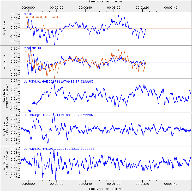
FOR4 Blundell West, UT, USA - Earthquake Result Viewer
*The percent match for this event was below the threshold and hence no stack was calculated.
| Earthquake location: |
Loyalty Islands |
| Earthquake latitude/longitude: |
-21.7/168.7 |
| Earthquake time(UTC): |
2017/11/19 (323) 09:25:47 GMT |
| Earthquake Depth: |
4.0 km |
| Earthquake Magnitude: |
6.3 mww |
| Earthquake Catalog/Contributor: |
NEIC PDE/us |
|
| Network: |
UU University of Utah Regional Network |
| Station: |
FOR4 Blundell West, UT, USA |
| Lat/Lon: |
38.50 N/112.90 W |
| Elevation: |
1657 m |
|
| Distance: |
94.6 deg |
| Az: |
50.458 deg |
| Baz: |
246.102 deg |
| Ray Param: |
$rayparam |
*The percent match for this event was below the threshold and hence was not used in the summary stack. |
|
| Radial Match: |
53.863148 % |
| Radial Bump: |
400 |
| Transverse Match: |
72.04782 % |
| Transverse Bump: |
400 |
| SOD ConfigId: |
2429771 |
| Insert Time: |
2017-12-03 09:28:13.831 +0000 |
| GWidth: |
2.5 |
| Max Bumps: |
400 |
| Tol: |
0.001 |
|
Signal To Noise
| Channel | StoN | STA | LTA |
| UU:FOR4:01:HHZ:20171119T09:38:37.329998Z | 4.8982487 | 1.611162E-8 | 3.2892613E-9 |
| UU:FOR4:01:HHN:20171119T09:38:37.329998Z | 2.4102652 | 1.5675317E-8 | 6.5035657E-9 |
| UU:FOR4:01:HHE:20171119T09:38:37.329998Z | 0.382681 | 8.030446E-9 | 2.0984698E-8 |
| Arrivals |
| Ps | |
| PpPs | |
| PsPs/PpSs | |


