You are here: Home > Network List > UU - University of Utah Regional Network Stations List
> Station FORU South Mineral Mountains, UT, USA > Earthquake Result Viewer
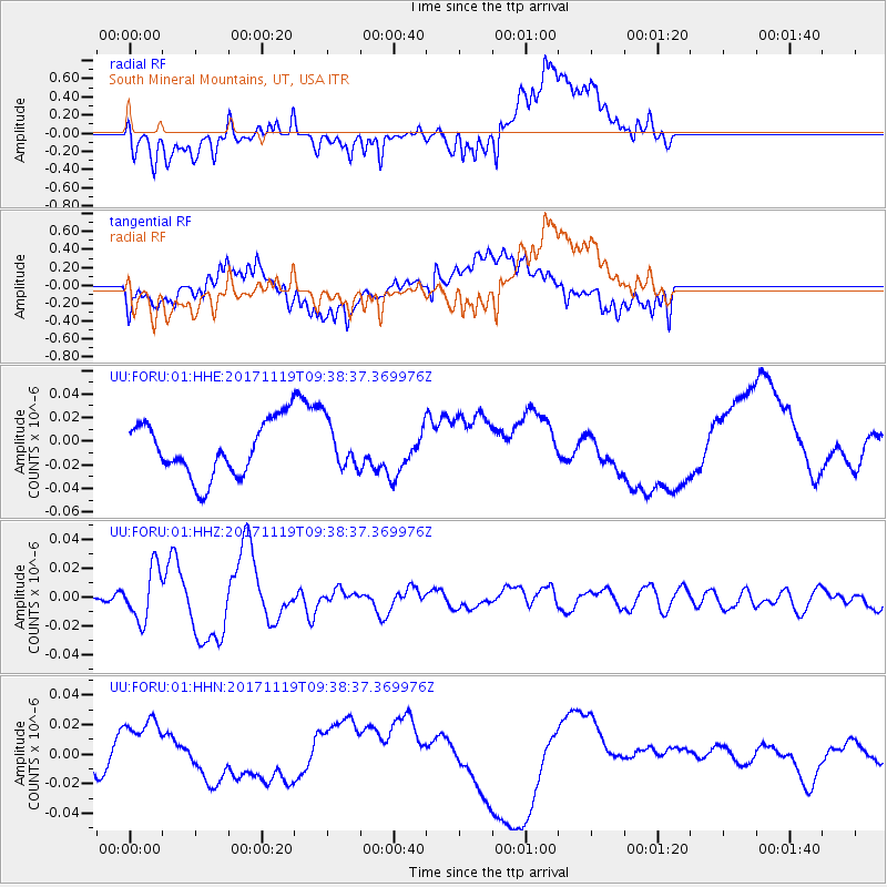
FORU South Mineral Mountains, UT, USA - Earthquake Result Viewer
*The percent match for this event was below the threshold and hence no stack was calculated.
| Earthquake location: |
Loyalty Islands |
| Earthquake latitude/longitude: |
-21.7/168.7 |
| Earthquake time(UTC): |
2017/11/19 (323) 09:25:47 GMT |
| Earthquake Depth: |
4.0 km |
| Earthquake Magnitude: |
6.3 mww |
| Earthquake Catalog/Contributor: |
NEIC PDE/us |
|
| Network: |
UU University of Utah Regional Network |
| Station: |
FORU South Mineral Mountains, UT, USA |
| Lat/Lon: |
38.46 N/112.86 W |
| Elevation: |
1840 m |
|
| Distance: |
94.6 deg |
| Az: |
50.505 deg |
| Baz: |
246.12 deg |
| Ray Param: |
$rayparam |
*The percent match for this event was below the threshold and hence was not used in the summary stack. |
|
| Radial Match: |
36.356945 % |
| Radial Bump: |
400 |
| Transverse Match: |
37.589855 % |
| Transverse Bump: |
400 |
| SOD ConfigId: |
2429771 |
| Insert Time: |
2017-12-03 09:28:16.566 +0000 |
| GWidth: |
2.5 |
| Max Bumps: |
400 |
| Tol: |
0.001 |
|
Signal To Noise
| Channel | StoN | STA | LTA |
| UU:FORU:01:HHZ:20171119T09:38:37.369976Z | 5.212984 | 1.8113717E-8 | 3.474731E-9 |
| UU:FORU:01:HHN:20171119T09:38:37.369976Z | 1.4261614 | 2.0817001E-8 | 1.4596526E-8 |
| UU:FORU:01:HHE:20171119T09:38:37.369976Z | 0.86832875 | 1.9909654E-8 | 2.2928704E-8 |
| Arrivals |
| Ps | |
| PpPs | |
| PsPs/PpSs | |


