You are here: Home > Network List > AV - Alaska Volcano Observatory Stations List
> Station KINC North Cape, Kanaga Volcano, Alaska > Earthquake Result Viewer
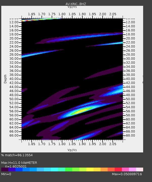
KINC North Cape, Kanaga Volcano, Alaska - Earthquake Result Viewer
| Earthquake location: |
Russia-Mongolia Border Region |
| Earthquake latitude/longitude: |
51.3/100.4 |
| Earthquake time(UTC): |
2021/05/03 (123) 08:46:39 GMT |
| Earthquake Depth: |
17 km |
| Earthquake Magnitude: |
5.6 Mww |
| Earthquake Catalog/Contributor: |
NEIC PDE/us |
|
| Network: |
AV Alaska Volcano Observatory |
| Station: |
KINC North Cape, Kanaga Volcano, Alaska |
| Lat/Lon: |
51.93 N/177.13 W |
| Elevation: |
198 m |
|
| Distance: |
48.5 deg |
| Az: |
55.017 deg |
| Baz: |
303.835 deg |
| Ray Param: |
0.06929668 |
| Estimated Moho Depth: |
11.0 km |
| Estimated Crust Vp/Vs: |
1.60 |
| Assumed Crust Vp: |
5.88 km/s |
| Estimated Crust Vs: |
3.67 km/s |
| Estimated Crust Poisson's Ratio: |
0.18 |
|
| Radial Match: |
96.13554 % |
| Radial Bump: |
106 |
| Transverse Match: |
99.23064 % |
| Transverse Bump: |
43 |
| SOD ConfigId: |
24844331 |
| Insert Time: |
2021-05-17 08:54:06.414 +0000 |
| GWidth: |
2.5 |
| Max Bumps: |
400 |
| Tol: |
0.001 |
|

Signal To Noise
| Channel | StoN | STA | LTA |
| AV:KINC: :BHZ:20210503T08:54:50.740012Z | 4.0784526 | 3.585324E-8 | 8.7908925E-9 |
| AV:KINC: :BHN:20210503T08:54:50.740012Z | 4.0075083 | 1.5452743E-8 | 3.855948E-9 |
| AV:KINC: :BHE:20210503T08:54:50.740012Z | 4.418758 | 2.5573296E-8 | 5.7874394E-9 |
| Arrivals |
| Ps | 1.2 SECOND |
| PpPs | 4.6 SECOND |
| PsPs/PpSs | 5.8 SECOND |


