You are here: Home > Network List > AV - Alaska Volcano Observatory Stations List
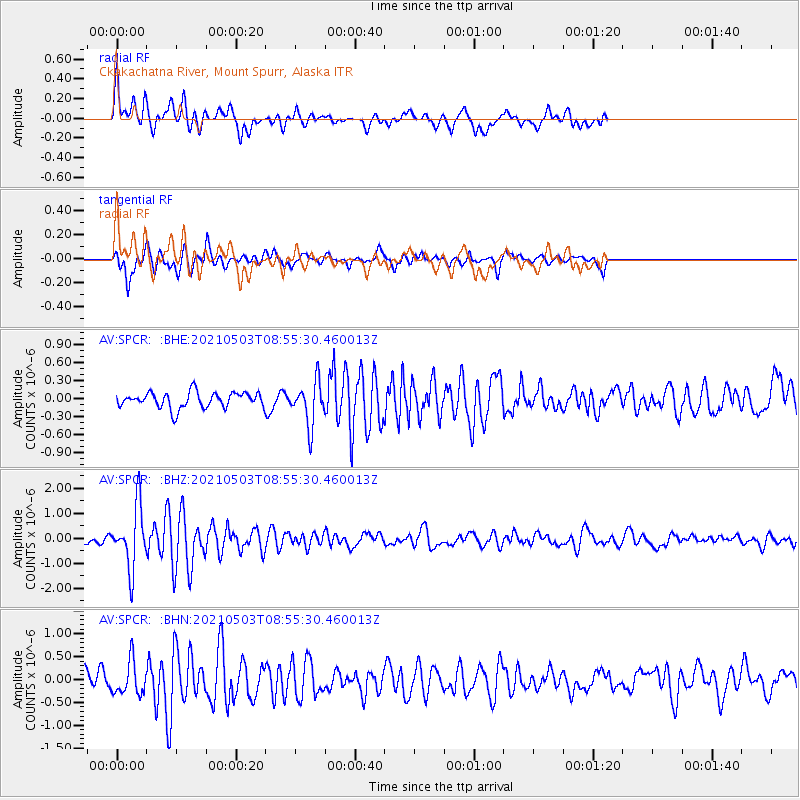
> Station SPCR Ckakachatna River, Mount Spurr, Alaska > Earthquake Result Viewer
SPCR Ckakachatna River, Mount Spurr, Alaska - Earthquake Result Viewer
| Earthquake location: |
Russia-Mongolia Border Region |
| Earthquake latitude/longitude: |
51.3/100.4 |
| Earthquake time(UTC): |
2021/05/03 (123) 08:46:39 GMT |
| Earthquake Depth: |
17 km |
| Earthquake Magnitude: |
5.6 Mww |
| Earthquake Catalog/Contributor: |
NEIC PDE/us |
|
| Network: |
AV Alaska Volcano Observatory |
| Station: |
SPCR Ckakachatna River, Mount Spurr, Alaska |
| Lat/Lon: |
61.20 N/152.21 W |
| Elevation: |
984 m |
|
| Distance: |
53.8 deg |
| Az: |
34.933 deg |
| Baz: |
312.071 deg |
| Ray Param: |
0.065834574 |
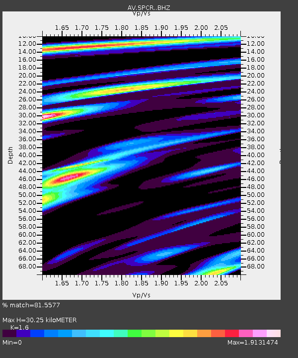
| Estimated Moho Depth: |
30.25 km |
| Estimated Crust Vp/Vs: |
1.60 |
| Assumed Crust Vp: |
6.566 km/s |
| Estimated Crust Vs: |
4.104 km/s |
| Estimated Crust Poisson's Ratio: |
0.18 |
|
| Radial Match: |
81.5577 % |
| Radial Bump: |
400 |
| Transverse Match: |
52.996277 % |
| Transverse Bump: |
398 |
| SOD ConfigId: |
24844331 |
| Insert Time: |
2021-05-17 08:54:30.503 +0000 |
| GWidth: |
2.5 |
| Max Bumps: |
400 |
| Tol: |
0.001 |
|
Signal To Noise
| Channel | StoN | STA | LTA |
| AV:SPCR: :BHZ:20210503T08:55:30.460013Z | 6.5948205 | 1.2180905E-6 | 1.8470412E-7 |
| AV:SPCR: :BHN:20210503T08:55:30.460013Z | 1.9661543 | 3.6313602E-7 | 1.8469355E-7 |
| AV:SPCR: :BHE:20210503T08:55:30.460013Z | 2.7647421 | 3.5620974E-7 | 1.2884013E-7 |
| Arrivals |
| Ps | 2.9 SECOND |
| PpPs | 11 SECOND |
| PsPs/PpSs | 14 SECOND |


