You are here: Home > Network List > CC - Cascade Chain Volcano Monitoring Stations List
> Station PR01 Puyallup River 01 > Earthquake Result Viewer
PR01 Puyallup River 01 - Earthquake Result Viewer
| Earthquake location: |
Russia-Mongolia Border Region |
| Earthquake latitude/longitude: |
51.3/100.4 |
| Earthquake time(UTC): |
2021/05/03 (123) 08:46:39 GMT |
| Earthquake Depth: |
17 km |
| Earthquake Magnitude: |
5.6 Mww |
| Earthquake Catalog/Contributor: |
NEIC PDE/us |
|
| Network: |
CC Cascade Chain Volcano Monitoring |
| Station: |
PR01 Puyallup River 01 |
| Lat/Lon: |
46.91 N/122.04 W |
| Elevation: |
648 m |
|
| Distance: |
75.6 deg |
| Az: |
28.554 deg |
| Baz: |
334.046 deg |
| Ray Param: |
0.05157516 |
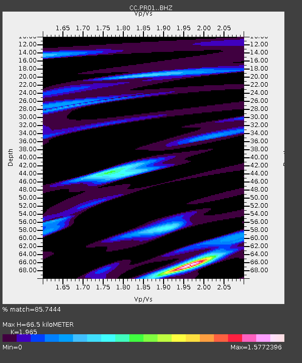
| Estimated Moho Depth: |
66.5 km |
| Estimated Crust Vp/Vs: |
1.97 |
| Assumed Crust Vp: |
6.566 km/s |
| Estimated Crust Vs: |
3.342 km/s |
| Estimated Crust Poisson's Ratio: |
0.33 |
|
| Radial Match: |
85.7444 % |
| Radial Bump: |
400 |
| Transverse Match: |
77.16178 % |
| Transverse Bump: |
400 |
| SOD ConfigId: |
24844331 |
| Insert Time: |
2021-05-17 08:56:15.462 +0000 |
| GWidth: |
2.5 |
| Max Bumps: |
400 |
| Tol: |
0.001 |
|

Signal To Noise
| Channel | StoN | STA | LTA |
| CC:PR01: :BHZ:20210503T08:57:52.04003Z | 3.421701 | 1.1826295E-6 | 3.456262E-7 |
| CC:PR01: :BHN:20210503T08:57:52.04003Z | 1.5504459 | 3.0944832E-7 | 1.9958668E-7 |
| CC:PR01: :BHE:20210503T08:57:52.04003Z | 1.9038024 | 4.8468746E-7 | 2.545892E-7 |
| Arrivals |
| Ps | 10 SECOND |
| PpPs | 29 SECOND |
| PsPs/PpSs | 39 SECOND |


