You are here: Home > Network List > XR08 - Seismic Investigation of Edge Driven Convection Associated with the Rio Grand Rift Stations List
> Station SC58 Andrews, TX USA > Earthquake Result Viewer
SC58 Andrews, TX USA - Earthquake Result Viewer
| Earthquake location: |
Kermadec Islands Region |
| Earthquake latitude/longitude: |
-27.4/-176.3 |
| Earthquake time(UTC): |
2009/02/18 (049) 21:53:45 GMT |
| Earthquake Depth: |
25 km |
| Earthquake Magnitude: |
6.8 MB, 7.2 MS, 6.9 MW, 6.9 MW |
| Earthquake Catalog/Contributor: |
WHDF/NEIC |
|
| Network: |
XR Seismic Investigation of Edge Driven Convection Associated with the Rio Grand Rift |
| Station: |
SC58 Andrews, TX USA |
| Lat/Lon: |
32.29 N/102.55 W |
| Elevation: |
10 m |
|
| Distance: |
91.9 deg |
| Az: |
54.462 deg |
| Baz: |
238.647 deg |
| Ray Param: |
0.04153327 |
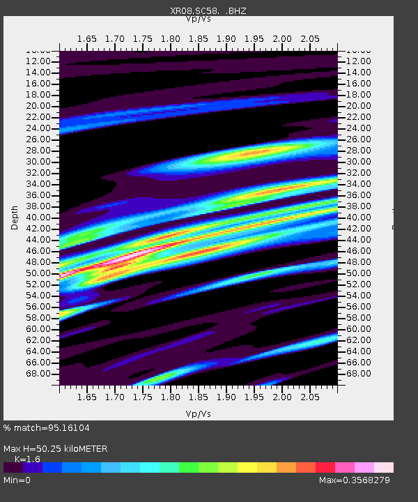
| Estimated Moho Depth: |
50.25 km |
| Estimated Crust Vp/Vs: |
1.60 |
| Assumed Crust Vp: |
6.129 km/s |
| Estimated Crust Vs: |
3.831 km/s |
| Estimated Crust Poisson's Ratio: |
0.18 |
|
| Radial Match: |
95.16104 % |
| Radial Bump: |
400 |
| Transverse Match: |
86.51565 % |
| Transverse Bump: |
400 |
| SOD ConfigId: |
2658 |
| Insert Time: |
2010-03-09 08:02:20.014 +0000 |
| GWidth: |
2.5 |
| Max Bumps: |
400 |
| Tol: |
0.001 |
|

Signal To Noise
| Channel | StoN | STA | LTA |
| XR:SC58: :BHZ:20090218T22:06:19.764004Z | 11.492582 | 2.317726E-6 | 2.0167148E-7 |
| XR:SC58: :BHN:20090218T22:06:19.764004Z | 1.786663 | 5.315951E-7 | 2.9753517E-7 |
| XR:SC58: :BHE:20090218T22:06:19.764004Z | 2.1339934 | 7.5928267E-7 | 3.5580365E-7 |
| Arrivals |
| Ps | 5.0 SECOND |
| PpPs | 21 SECOND |
| PsPs/PpSs | 26 SECOND |


