You are here: Home > Network List > XR08 - Seismic Investigation of Edge Driven Convection Associated with the Rio Grand Rift Stations List
> Station SC58 Andrews, TX USA > Earthquake Result Viewer
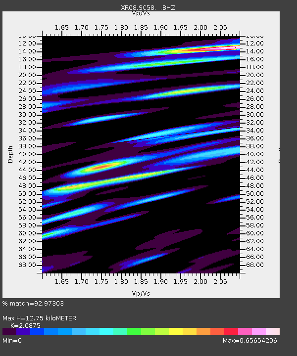
SC58 Andrews, TX USA - Earthquake Result Viewer
| Earthquake location: |
Hokkaido, Japan Region |
| Earthquake latitude/longitude: |
41.8/143.4 |
| Earthquake time(UTC): |
2009/06/05 (156) 03:30:33 GMT |
| Earthquake Depth: |
29 km |
| Earthquake Magnitude: |
6.0 MB, 6.3 MS, 6.4 MW, 6.4 MW |
| Earthquake Catalog/Contributor: |
WHDF/NEIC |
|
| Network: |
XR Seismic Investigation of Edge Driven Convection Associated with the Rio Grand Rift |
| Station: |
SC58 Andrews, TX USA |
| Lat/Lon: |
32.29 N/102.55 W |
| Elevation: |
10 m |
|
| Distance: |
84.5 deg |
| Az: |
51.012 deg |
| Baz: |
316.693 deg |
| Ray Param: |
0.04539402 |
| Estimated Moho Depth: |
12.75 km |
| Estimated Crust Vp/Vs: |
2.09 |
| Assumed Crust Vp: |
6.129 km/s |
| Estimated Crust Vs: |
2.936 km/s |
| Estimated Crust Poisson's Ratio: |
0.35 |
|
| Radial Match: |
92.97303 % |
| Radial Bump: |
310 |
| Transverse Match: |
77.810524 % |
| Transverse Bump: |
400 |
| SOD ConfigId: |
2648 |
| Insert Time: |
2010-03-09 08:02:21.725 +0000 |
| GWidth: |
2.5 |
| Max Bumps: |
400 |
| Tol: |
0.001 |
|

Signal To Noise
| Channel | StoN | STA | LTA |
| XR:SC58: :BHZ:20090605T03:42:31.914004Z | 8.994778 | 9.2035947E-7 | 1.02321536E-7 |
| XR:SC58: :BHN:20090605T03:42:31.914004Z | 2.423939 | 2.535818E-7 | 1.0461558E-7 |
| XR:SC58: :BHE:20090605T03:42:31.914004Z | 2.5802689 | 2.3732738E-7 | 9.1977775E-8 |
| Arrivals |
| Ps | 2.3 SECOND |
| PpPs | 6.3 SECOND |
| PsPs/PpSs | 8.6 SECOND |


