You are here: Home > Network List > AV - Alaska Volcano Observatory Stations List
> Station MAPS Pakushin Southeast, Makushin Volcano, Alaska > Earthquake Result Viewer
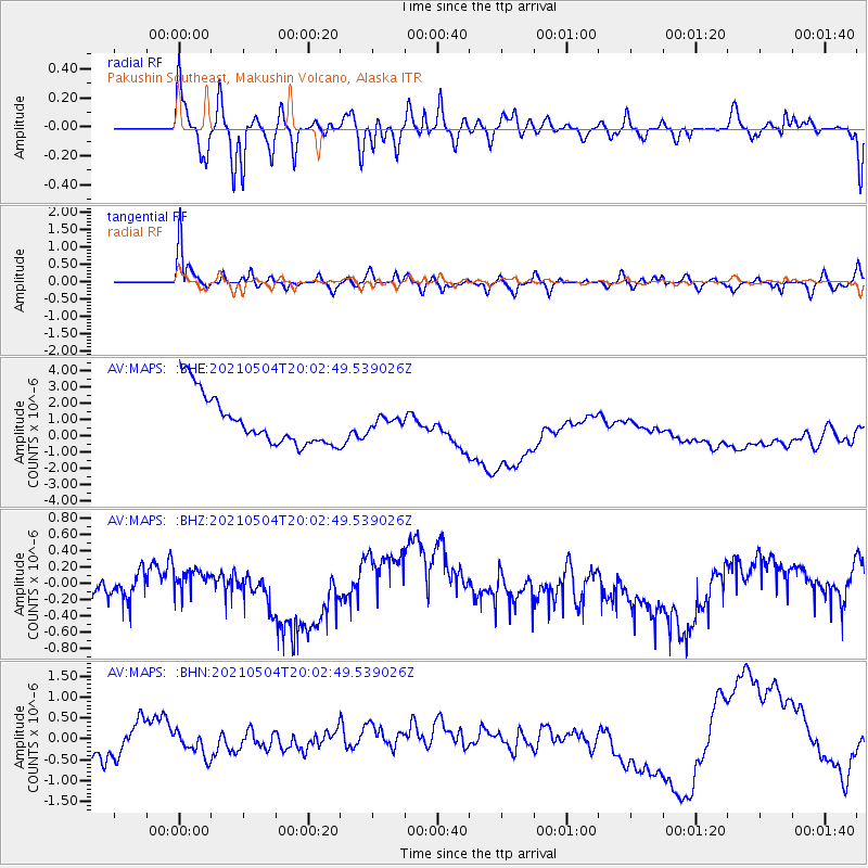
MAPS Pakushin Southeast, Makushin Volcano, Alaska - Earthquake Result Viewer
*The percent match for this event was below the threshold and hence no stack was calculated.
| Earthquake location: |
Tonga Islands |
| Earthquake latitude/longitude: |
-20.7/-173.8 |
| Earthquake time(UTC): |
2021/05/04 (124) 19:51:42 GMT |
| Earthquake Depth: |
10 km |
| Earthquake Magnitude: |
5.5 mww |
| Earthquake Catalog/Contributor: |
NEIC PDE/us |
|
| Network: |
AV Alaska Volcano Observatory |
| Station: |
MAPS Pakushin Southeast, Makushin Volcano, Alaska |
| Lat/Lon: |
53.81 N/166.94 W |
| Elevation: |
333 m |
|
| Distance: |
74.5 deg |
| Az: |
4.2 deg |
| Baz: |
186.638 deg |
| Ray Param: |
$rayparam |
*The percent match for this event was below the threshold and hence was not used in the summary stack. |
|
| Radial Match: |
50.965958 % |
| Radial Bump: |
400 |
| Transverse Match: |
78.21339 % |
| Transverse Bump: |
400 |
| SOD ConfigId: |
24844331 |
| Insert Time: |
2021-05-18 19:58:08.294 +0000 |
| GWidth: |
2.5 |
| Max Bumps: |
400 |
| Tol: |
0.001 |
|
Signal To Noise
| Channel | StoN | STA | LTA |
| AV:MAPS: :BHZ:20210504T20:02:49.539026Z | 0.44099915 | 3.1422493E-7 | 7.125296E-7 |
| AV:MAPS: :BHN:20210504T20:02:49.539026Z | 0.5873546 | 2.6083978E-7 | 4.4409254E-7 |
| AV:MAPS: :BHE:20210504T20:02:49.539026Z | 0.20317976 | 3.1006783E-7 | 1.5260764E-6 |
| Arrivals |
| Ps | |
| PpPs | |
| PsPs/PpSs | |


