You are here: Home > Network List > AV - Alaska Volcano Observatory Stations List
> Station MAPS Pakushin Southeast, Makushin Volcano, Alaska > Earthquake Result Viewer
MAPS Pakushin Southeast, Makushin Volcano, Alaska - Earthquake Result Viewer

| Earthquake location: |
Southern Sumatra, Indonesia |
| Earthquake latitude/longitude: |
-2.0/99.7 |
| Earthquake time(UTC): |
2021/05/05 (125) 01:24:35 GMT |
| Earthquake Depth: |
23 km |
| Earthquake Magnitude: |
5.7 mww |
| Earthquake Catalog/Contributor: |
NEIC PDE/us |
|
| Network: |
AV Alaska Volcano Observatory |
| Station: |
MAPS Pakushin Southeast, Makushin Volcano, Alaska |
| Lat/Lon: |
53.81 N/166.94 W |
| Elevation: |
333 m |
|
| Distance: |
93.6 deg |
| Az: |
36.386 deg |
| Baz: |
271.508 deg |
| Ray Param: |
0.041228864 |
| Estimated Moho Depth: |
55.5 km |
| Estimated Crust Vp/Vs: |
1.66 |
| Assumed Crust Vp: |
3.943 km/s |
| Estimated Crust Vs: |
2.379 km/s |
| Estimated Crust Poisson's Ratio: |
0.21 |
|
| Radial Match: |
90.68476 % |
| Radial Bump: |
351 |
| Transverse Match: |
65.418655 % |
| Transverse Bump: |
400 |
| SOD ConfigId: |
24844331 |
| Insert Time: |
2021-05-19 01:28:06.101 +0000 |
| GWidth: |
2.5 |
| Max Bumps: |
400 |
| Tol: |
0.001 |
|
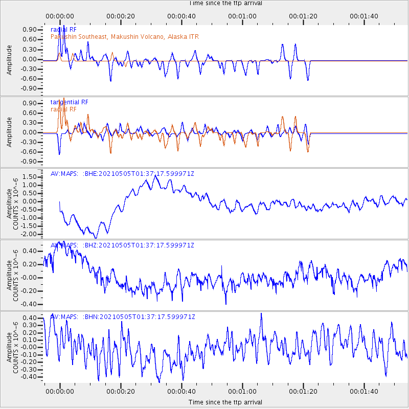
Signal To Noise
| Channel | StoN | STA | LTA |
| AV:MAPS: :BHZ:20210505T01:37:17.599971Z | 2.2162871 | 7.1870653E-7 | 3.2428403E-7 |
| AV:MAPS: :BHN:20210505T01:37:17.599971Z | 0.3937808 | 1.6812344E-7 | 4.2694674E-7 |
| AV:MAPS: :BHE:20210505T01:37:17.599971Z | 2.6562245 | 2.0807402E-6 | 7.83345E-7 |
| Arrivals |
| Ps | 9.3 SECOND |
| PpPs | 37 SECOND |
| PsPs/PpSs | 46 SECOND |


