You are here: Home > Network List > UU - University of Utah Regional Network Stations List
> Station CCUT Cedar City, UT, USA > Earthquake Result Viewer
CCUT Cedar City, UT, USA - Earthquake Result Viewer
| Earthquake location: |
Loyalty Islands |
| Earthquake latitude/longitude: |
-21.5/168.5 |
| Earthquake time(UTC): |
2017/11/19 (323) 15:09:03 GMT |
| Earthquake Depth: |
14 km |
| Earthquake Magnitude: |
6.6 mww |
| Earthquake Catalog/Contributor: |
NEIC PDE/us |
|
| Network: |
UU University of Utah Regional Network |
| Station: |
CCUT Cedar City, UT, USA |
| Lat/Lon: |
37.55 N/113.36 W |
| Elevation: |
2127 m |
|
| Distance: |
93.9 deg |
| Az: |
51.218 deg |
| Baz: |
245.961 deg |
| Ray Param: |
0.041157793 |
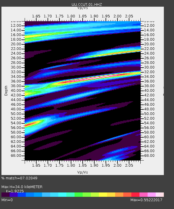
| Estimated Moho Depth: |
34.0 km |
| Estimated Crust Vp/Vs: |
1.92 |
| Assumed Crust Vp: |
6.194 km/s |
| Estimated Crust Vs: |
3.222 km/s |
| Estimated Crust Poisson's Ratio: |
0.31 |
|
| Radial Match: |
87.02849 % |
| Radial Bump: |
400 |
| Transverse Match: |
64.23721 % |
| Transverse Bump: |
400 |
| SOD ConfigId: |
2429771 |
| Insert Time: |
2017-12-03 15:11:18.667 +0000 |
| GWidth: |
2.5 |
| Max Bumps: |
400 |
| Tol: |
0.001 |
|
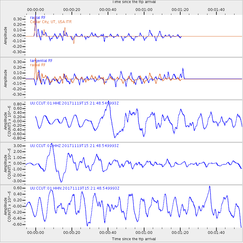
Signal To Noise
| Channel | StoN | STA | LTA |
| UU:CCUT:01:HHZ:20171119T15:21:48.549993Z | 2.5793672 | 5.3905353E-7 | 2.0898675E-7 |
| UU:CCUT:01:HHN:20171119T15:21:48.549993Z | 1.5469369 | 2.4294792E-7 | 1.5705096E-7 |
| UU:CCUT:01:HHE:20171119T15:21:48.549993Z | 1.4960825 | 2.5436137E-7 | 1.7001827E-7 |
| Arrivals |
| Ps | 5.2 SECOND |
| PpPs | 16 SECOND |
| PsPs/PpSs | 21 SECOND |


