You are here: Home > Network List > GO - National Seismic Network of Georgia Stations List
> Station TBLG Delisi, Georgia > Earthquake Result Viewer
TBLG Delisi, Georgia - Earthquake Result Viewer
| Earthquake location: |
Southern Sumatra, Indonesia |
| Earthquake latitude/longitude: |
-2.0/99.7 |
| Earthquake time(UTC): |
2021/05/05 (125) 01:24:35 GMT |
| Earthquake Depth: |
23 km |
| Earthquake Magnitude: |
5.7 mww |
| Earthquake Catalog/Contributor: |
NEIC PDE/us |
|
| Network: |
GO National Seismic Network of Georgia |
| Station: |
TBLG Delisi, Georgia |
| Lat/Lon: |
41.73 N/44.74 E |
| Elevation: |
510 m |
|
| Distance: |
66.0 deg |
| Az: |
317.872 deg |
| Baz: |
116.41 deg |
| Ray Param: |
0.057855833 |
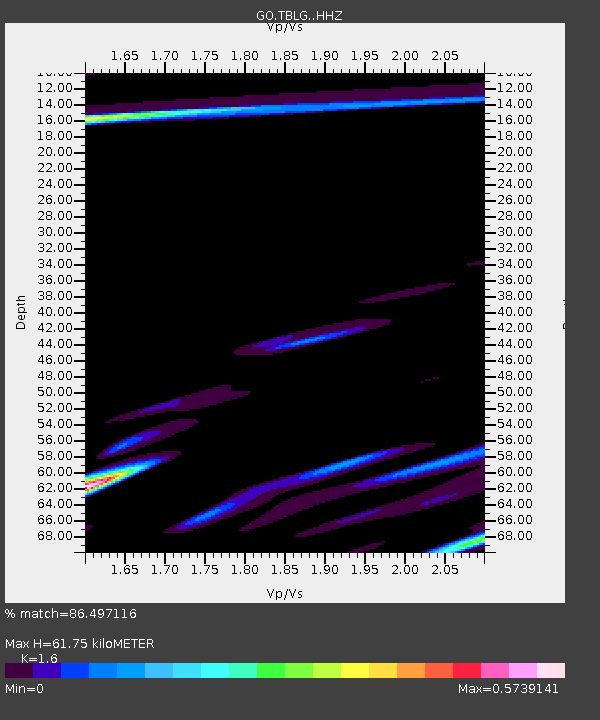
| Estimated Moho Depth: |
61.75 km |
| Estimated Crust Vp/Vs: |
1.60 |
| Assumed Crust Vp: |
6.291 km/s |
| Estimated Crust Vs: |
3.932 km/s |
| Estimated Crust Poisson's Ratio: |
0.18 |
|
| Radial Match: |
86.497116 % |
| Radial Bump: |
400 |
| Transverse Match: |
83.224525 % |
| Transverse Bump: |
400 |
| SOD ConfigId: |
24844331 |
| Insert Time: |
2021-05-19 01:29:29.264 +0000 |
| GWidth: |
2.5 |
| Max Bumps: |
400 |
| Tol: |
0.001 |
|
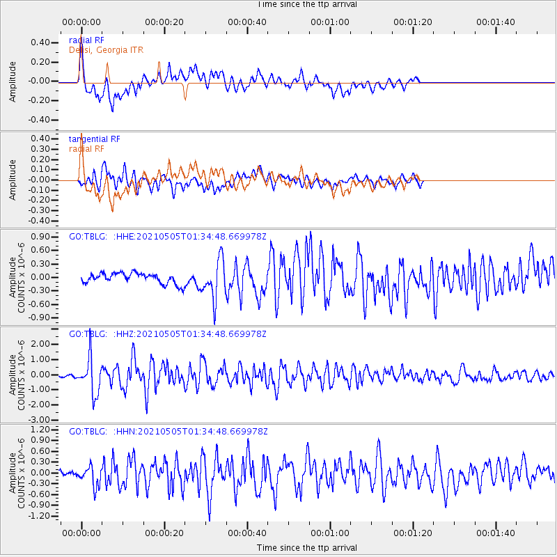
Signal To Noise
| Channel | StoN | STA | LTA |
| GO:TBLG: :HHZ:20210505T01:34:48.669978Z | 15.568708 | 1.2099486E-6 | 7.77167E-8 |
| GO:TBLG: :HHN:20210505T01:34:48.669978Z | 3.1591842 | 2.7413256E-7 | 8.677321E-8 |
| GO:TBLG: :HHE:20210505T01:34:48.669978Z | 3.8579376 | 4.4495303E-7 | 1.1533443E-7 |
| Arrivals |
| Ps | 6.2 SECOND |
| PpPs | 24 SECOND |
| PsPs/PpSs | 31 SECOND |


