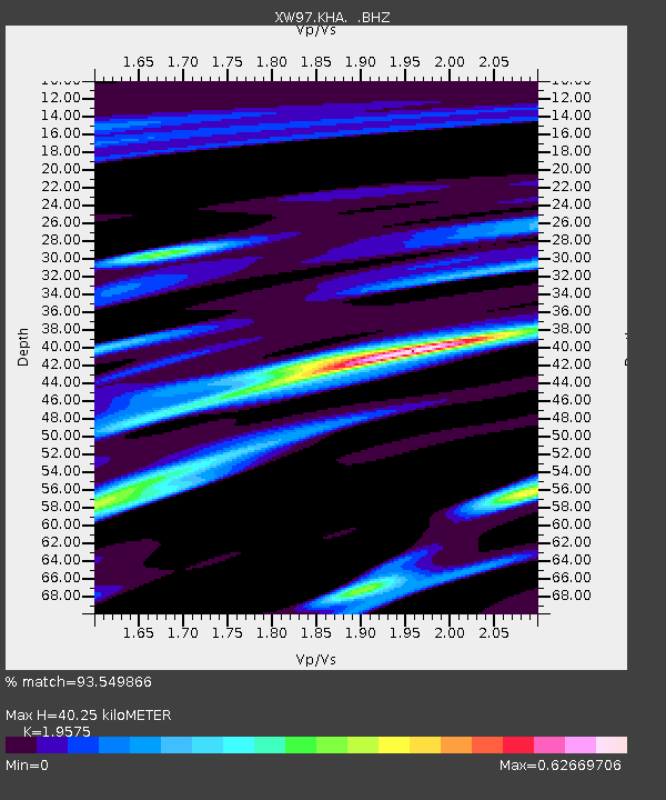
KHA XW.KHA - Earthquake Result Viewer

Earthquake location: South Of Mariana Islands
Earthquake latitude/longitude: 11.8/143.2
Earthquake time(UTC): 1998/09/22 (265) 01:16:55 GMT
Earthquake Depth: 9.0 km
Earthquake Magnitude: 5.8 MB, 5.8 MS, 6.1 UNKNOWN, 6.0 MW
Earthquake Catalog/Contributor: WHDF/NEIC
Network: XW Tien Shan Continental Dynamics
Station: KHA XW.KHA
Lat/Lon: 44.21 N/74.00 E
Elevation: 1014 m
Distance: 66.9 deg
Az: 313.068 deg
Baz: 95.969 deg
Ray Param: 0.057295967
Estimated Moho Depth: 40.25 km
Estimated Crust Vp/Vs: 1.96
Assumed Crust Vp: 6.35 km/s
Estimated Crust Vs: 3.244 km/s
Estimated Crust Poisson's Ratio: 0.32
Radial Match: 93.549866 %
Radial Bump: 400
Transverse Match: 77.9856 %
Transverse Bump: 400
SOD ConfigId: 4480
Insert Time: 2010-02-26 15:34:08.799 +0000
GWidth: 2.5
Max Bumps: 400
Tol: 0.001

Signal To Noise

ChannelStoNSTALTA
XW:KHA: :BHZ:19980922T01:27:16.801001Z7.19849545.0482134E-77.012873E-8
XW:KHA: :BHN:19980922T01:27:16.801001Z0.72175393.2258157E-84.4694126E-8
XW:KHA: :BHE:19980922T01:27:16.801001Z3.61627722.2784606E-76.300569E-8
Arrivals
Ps6.3 SECOND
PpPs18 SECOND
PsPs/PpSs24 SECOND