You are here: Home > Network List > CI - Caltech Regional Seismic Network Stations List
> Station TIN Tinemaha, Big Pine, CA, USA > Earthquake Result Viewer
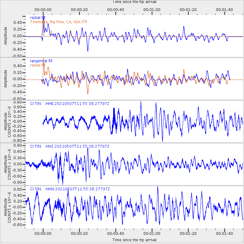
TIN Tinemaha, Big Pine, CA, USA - Earthquake Result Viewer
*The percent match for this event was below the threshold and hence no stack was calculated.
| Earthquake location: |
North Atlantic Ocean |
| Earthquake latitude/longitude: |
14.1/-48.4 |
| Earthquake time(UTC): |
2021/05/07 (127) 11:45:25 GMT |
| Earthquake Depth: |
10 km |
| Earthquake Magnitude: |
5.5 mww |
| Earthquake Catalog/Contributor: |
NEIC PDE/us |
|
| Network: |
CI Caltech Regional Seismic Network |
| Station: |
TIN Tinemaha, Big Pine, CA, USA |
| Lat/Lon: |
37.05 N/118.23 W |
| Elevation: |
1197 m |
|
| Distance: |
65.6 deg |
| Az: |
304.465 deg |
| Baz: |
90.459 deg |
| Ray Param: |
$rayparam |
*The percent match for this event was below the threshold and hence was not used in the summary stack. |
|
| Radial Match: |
70.38523 % |
| Radial Bump: |
400 |
| Transverse Match: |
48.79635 % |
| Transverse Bump: |
400 |
| SOD ConfigId: |
24844331 |
| Insert Time: |
2021-05-21 11:55:49.623 +0000 |
| GWidth: |
2.5 |
| Max Bumps: |
400 |
| Tol: |
0.001 |
|
Signal To Noise
| Channel | StoN | STA | LTA |
| CI:TIN: :HHZ:20210507T11:55:38.27797Z | 0.88882375 | 1.0129292E-7 | 1.1396288E-7 |
| CI:TIN: :HHN:20210507T11:55:38.27797Z | 0.74878883 | 2.0860136E-7 | 2.7858505E-7 |
| CI:TIN: :HHE:20210507T11:55:38.27797Z | 1.3068951 | 1.766559E-7 | 1.351722E-7 |
| Arrivals |
| Ps | |
| PpPs | |
| PsPs/PpSs | |


