You are here: Home > Network List > GO - National Seismic Network of Georgia Stations List
> Station TBLG Delisi, Georgia > Earthquake Result Viewer
TBLG Delisi, Georgia - Earthquake Result Viewer
| Earthquake location: |
North Atlantic Ocean |
| Earthquake latitude/longitude: |
14.1/-48.4 |
| Earthquake time(UTC): |
2021/05/07 (127) 11:45:25 GMT |
| Earthquake Depth: |
10 km |
| Earthquake Magnitude: |
5.5 mww |
| Earthquake Catalog/Contributor: |
NEIC PDE/us |
|
| Network: |
GO National Seismic Network of Georgia |
| Station: |
TBLG Delisi, Georgia |
| Lat/Lon: |
41.73 N/44.74 E |
| Elevation: |
510 m |
|
| Distance: |
83.1 deg |
| Az: |
48.838 deg |
| Baz: |
282.594 deg |
| Ray Param: |
0.0464457 |
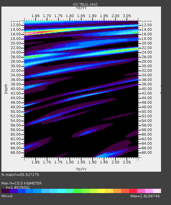
| Estimated Moho Depth: |
15.5 km |
| Estimated Crust Vp/Vs: |
1.60 |
| Assumed Crust Vp: |
6.291 km/s |
| Estimated Crust Vs: |
3.926 km/s |
| Estimated Crust Poisson's Ratio: |
0.18 |
|
| Radial Match: |
85.527275 % |
| Radial Bump: |
267 |
| Transverse Match: |
55.365387 % |
| Transverse Bump: |
338 |
| SOD ConfigId: |
24844331 |
| Insert Time: |
2021-05-21 11:58:43.342 +0000 |
| GWidth: |
2.5 |
| Max Bumps: |
400 |
| Tol: |
0.001 |
|

Signal To Noise
| Channel | StoN | STA | LTA |
| GO:TBLG: :HHZ:20210507T11:57:19.680009Z | 2.812304 | 4.234373E-7 | 1.5056598E-7 |
| GO:TBLG: :HHN:20210507T11:57:19.680009Z | 2.4471247 | 3.5815495E-7 | 1.4635745E-7 |
| GO:TBLG: :HHE:20210507T11:57:19.680009Z | 2.199258 | 9.74179E-7 | 4.42958E-7 |
| Arrivals |
| Ps | 1.5 SECOND |
| PpPs | 6.2 SECOND |
| PsPs/PpSs | 7.8 SECOND |


