You are here: Home > Network List > TX - Texas Seismological Network Stations List
> Station HNDO Hondo > Earthquake Result Viewer
HNDO Hondo - Earthquake Result Viewer
| Earthquake location: |
North Atlantic Ocean |
| Earthquake latitude/longitude: |
14.1/-48.4 |
| Earthquake time(UTC): |
2021/05/07 (127) 11:45:25 GMT |
| Earthquake Depth: |
10 km |
| Earthquake Magnitude: |
5.5 mww |
| Earthquake Catalog/Contributor: |
NEIC PDE/us |
|
| Network: |
TX Texas Seismological Network |
| Station: |
HNDO Hondo |
| Lat/Lon: |
29.53 N/99.28 W |
| Elevation: |
381 m |
|
| Distance: |
49.3 deg |
| Az: |
296.882 deg |
| Baz: |
96.775 deg |
| Ray Param: |
0.068809055 |
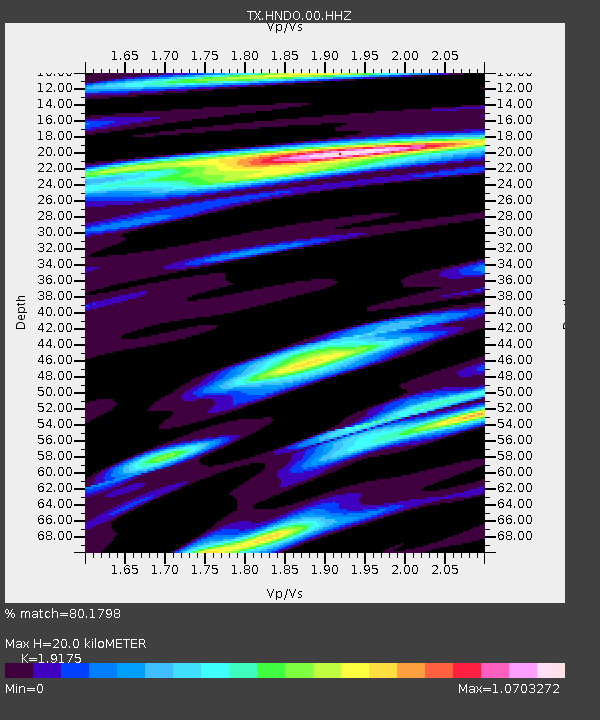
| Estimated Moho Depth: |
20.0 km |
| Estimated Crust Vp/Vs: |
1.92 |
| Assumed Crust Vp: |
6.347 km/s |
| Estimated Crust Vs: |
3.31 km/s |
| Estimated Crust Poisson's Ratio: |
0.31 |
|
| Radial Match: |
80.1798 % |
| Radial Bump: |
400 |
| Transverse Match: |
66.2205 % |
| Transverse Bump: |
375 |
| SOD ConfigId: |
24844331 |
| Insert Time: |
2021-05-21 12:09:37.260 +0000 |
| GWidth: |
2.5 |
| Max Bumps: |
400 |
| Tol: |
0.001 |
|

Signal To Noise
| Channel | StoN | STA | LTA |
| TX:HNDO:00:HHZ:20210507T11:53:43.370011Z | 3.0800233 | 4.6504906E-7 | 1.5098881E-7 |
| TX:HNDO:00:HH1:20210507T11:53:43.370011Z | 1.8484659 | 1.7243502E-7 | 9.328548E-8 |
| TX:HNDO:00:HH2:20210507T11:53:43.370011Z | 3.8293874 | 2.1462483E-7 | 5.604678E-8 |
| Arrivals |
| Ps | 3.0 SECOND |
| PpPs | 8.7 SECOND |
| PsPs/PpSs | 12 SECOND |


