You are here: Home > Network List > US - United States National Seismic Network Stations List
> Station AMTX Amarillo, Texas, USA > Earthquake Result Viewer
AMTX Amarillo, Texas, USA - Earthquake Result Viewer
*The percent match for this event was below the threshold and hence no stack was calculated.
| Earthquake location: |
North Atlantic Ocean |
| Earthquake latitude/longitude: |
14.1/-48.4 |
| Earthquake time(UTC): |
2021/05/07 (127) 11:45:25 GMT |
| Earthquake Depth: |
10 km |
| Earthquake Magnitude: |
5.5 mww |
| Earthquake Catalog/Contributor: |
NEIC PDE/us |
|
| Network: |
US United States National Seismic Network |
| Station: |
AMTX Amarillo, Texas, USA |
| Lat/Lon: |
34.53 N/101.41 W |
| Elevation: |
1010 m |
|
| Distance: |
51.8 deg |
| Az: |
302.945 deg |
| Baz: |
99.507 deg |
| Ray Param: |
$rayparam |
*The percent match for this event was below the threshold and hence was not used in the summary stack. |
|
| Radial Match: |
59.99984 % |
| Radial Bump: |
400 |
| Transverse Match: |
59.921333 % |
| Transverse Bump: |
400 |
| SOD ConfigId: |
24844331 |
| Insert Time: |
2021-05-21 12:10:37.094 +0000 |
| GWidth: |
2.5 |
| Max Bumps: |
400 |
| Tol: |
0.001 |
|
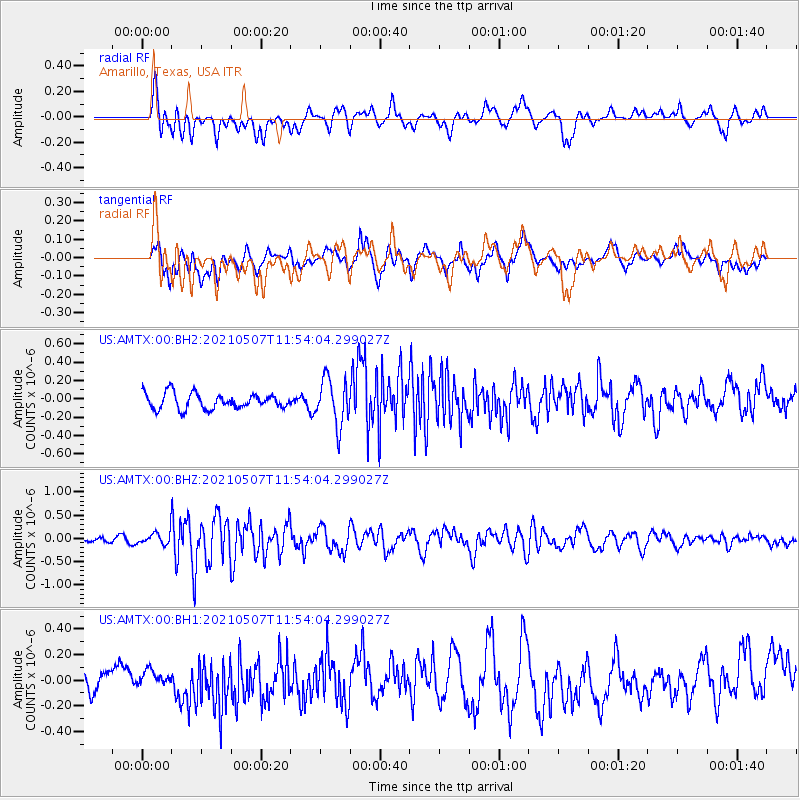
Signal To Noise
| Channel | StoN | STA | LTA |
| US:AMTX:00:BHZ:20210507T11:54:04.299027Z | 1.1499841 | 1.5841921E-7 | 1.3775774E-7 |
| US:AMTX:00:BH1:20210507T11:54:04.299027Z | 0.5714855 | 4.8874128E-8 | 8.55212E-8 |
| US:AMTX:00:BH2:20210507T11:54:04.299027Z | 2.197965 | 1.8845674E-7 | 8.574146E-8 |
| Arrivals |
| Ps | |
| PpPs | |
| PsPs/PpSs | |


