You are here: Home > Network List > US - United States National Seismic Network Stations List
> Station OGNE Ogallala, Nebraska, USA > Earthquake Result Viewer
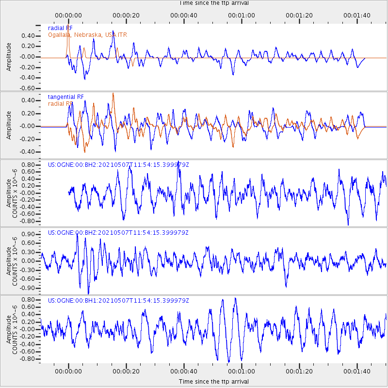
OGNE Ogallala, Nebraska, USA - Earthquake Result Viewer
*The percent match for this event was below the threshold and hence no stack was calculated.
| Earthquake location: |
North Atlantic Ocean |
| Earthquake latitude/longitude: |
14.1/-48.4 |
| Earthquake time(UTC): |
2021/05/07 (127) 11:45:25 GMT |
| Earthquake Depth: |
10 km |
| Earthquake Magnitude: |
5.5 mww |
| Earthquake Catalog/Contributor: |
NEIC PDE/us |
|
| Network: |
US United States National Seismic Network |
| Station: |
OGNE Ogallala, Nebraska, USA |
| Lat/Lon: |
40.95 N/102.03 W |
| Elevation: |
1054 m |
|
| Distance: |
53.6 deg |
| Az: |
310.708 deg |
| Baz: |
103.838 deg |
| Ray Param: |
$rayparam |
*The percent match for this event was below the threshold and hence was not used in the summary stack. |
|
| Radial Match: |
58.484745 % |
| Radial Bump: |
400 |
| Transverse Match: |
68.34242 % |
| Transverse Bump: |
400 |
| SOD ConfigId: |
24844331 |
| Insert Time: |
2021-05-21 12:11:11.394 +0000 |
| GWidth: |
2.5 |
| Max Bumps: |
400 |
| Tol: |
0.001 |
|
Signal To Noise
| Channel | StoN | STA | LTA |
| US:OGNE:00:BHZ:20210507T11:54:15.399979Z | 3.054811 | 3.8676478E-7 | 1.2660841E-7 |
| US:OGNE:00:BH1:20210507T11:54:15.399979Z | 0.8681611 | 2.6598372E-7 | 3.06376E-7 |
| US:OGNE:00:BH2:20210507T11:54:15.399979Z | 0.63600314 | 1.9844191E-7 | 3.1201404E-7 |
| Arrivals |
| Ps | |
| PpPs | |
| PsPs/PpSs | |


