You are here: Home > Network List > XW97 - Tien Shan Continental Dynamics Stations List
> Station KHA XW.KHA > Earthquake Result Viewer
KHA XW.KHA - Earthquake Result Viewer
| Earthquake location: |
Banda Sea |
| Earthquake latitude/longitude: |
-7.0/129.0 |
| Earthquake time(UTC): |
1998/11/09 (313) 05:30:14 GMT |
| Earthquake Depth: |
33 km |
| Earthquake Magnitude: |
6.1 MB, 6.7 UNKNOWN, 6.6 ME |
| Earthquake Catalog/Contributor: |
WHDF/NEIC |
|
| Network: |
XW Tien Shan Continental Dynamics |
| Station: |
KHA XW.KHA |
| Lat/Lon: |
44.21 N/74.00 E |
| Elevation: |
1014 m |
|
| Distance: |
71.0 deg |
| Az: |
321.446 deg |
| Baz: |
120.644 deg |
| Ray Param: |
0.05456465 |
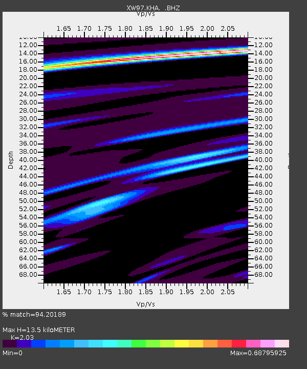
| Estimated Moho Depth: |
13.5 km |
| Estimated Crust Vp/Vs: |
2.03 |
| Assumed Crust Vp: |
6.35 km/s |
| Estimated Crust Vs: |
3.128 km/s |
| Estimated Crust Poisson's Ratio: |
0.34 |
|
| Radial Match: |
94.20189 % |
| Radial Bump: |
307 |
| Transverse Match: |
82.520004 % |
| Transverse Bump: |
400 |
| SOD ConfigId: |
4480 |
| Insert Time: |
2010-02-26 15:34:19.187 +0000 |
| GWidth: |
2.5 |
| Max Bumps: |
400 |
| Tol: |
0.001 |
|

Signal To Noise
| Channel | StoN | STA | LTA |
| XW:KHA: :BHZ:19981109T05:40:57.847021Z | 8.180011 | 8.3983724E-7 | 1.0266945E-7 |
| XW:KHA: :BHN:19981109T05:40:57.847021Z | 1.484674 | 2.785829E-7 | 1.8763909E-7 |
| XW:KHA: :BHE:19981109T05:40:57.847021Z | 1.4842279 | 4.3911223E-7 | 2.958523E-7 |
| Arrivals |
| Ps | 2.3 SECOND |
| PpPs | 6.2 SECOND |
| PsPs/PpSs | 8.5 SECOND |


