You are here: Home > Network List > AV - Alaska Volcano Observatory Stations List
> Station MAPS Pakushin Southeast, Makushin Volcano, Alaska > Earthquake Result Viewer
MAPS Pakushin Southeast, Makushin Volcano, Alaska - Earthquake Result Viewer
| Earthquake location: |
Fiji Islands Region |
| Earthquake latitude/longitude: |
-18.8/-177.5 |
| Earthquake time(UTC): |
2021/05/07 (127) 23:35:14 GMT |
| Earthquake Depth: |
384 km |
| Earthquake Magnitude: |
6.1 Mww |
| Earthquake Catalog/Contributor: |
NEIC PDE/us |
|
| Network: |
AV Alaska Volcano Observatory |
| Station: |
MAPS Pakushin Southeast, Makushin Volcano, Alaska |
| Lat/Lon: |
53.81 N/166.94 W |
| Elevation: |
333 m |
|
| Distance: |
72.9 deg |
| Az: |
6.522 deg |
| Baz: |
190.452 deg |
| Ray Param: |
0.05222213 |
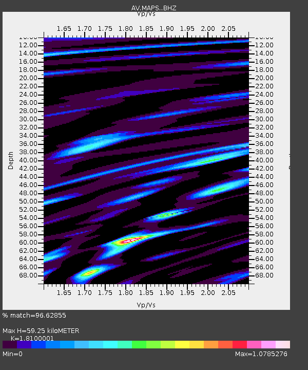
| Estimated Moho Depth: |
59.25 km |
| Estimated Crust Vp/Vs: |
1.81 |
| Assumed Crust Vp: |
3.943 km/s |
| Estimated Crust Vs: |
2.179 km/s |
| Estimated Crust Poisson's Ratio: |
0.28 |
|
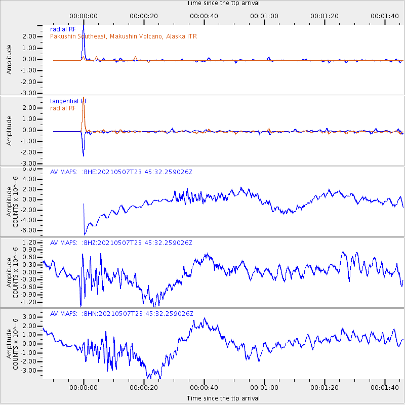
| Radial Match: |
96.62855 % |
| Radial Bump: |
238 |
| Transverse Match: |
85.97158 % |
| Transverse Bump: |
297 |
| SOD ConfigId: |
24844331 |
| Insert Time: |
2021-05-21 23:44:45.191 +0000 |
| GWidth: |
2.5 |
| Max Bumps: |
400 |
| Tol: |
0.001 |
|
Signal To Noise
| Channel | StoN | STA | LTA |
| AV:MAPS: :BHZ:20210507T23:45:32.259026Z | 1.2583026 | 1.496309E-6 | 1.1891487E-6 |
| AV:MAPS: :BHN:20210507T23:45:32.259026Z | 1.3421268 | 4.1531653E-6 | 3.0944655E-6 |
| AV:MAPS: :BHE:20210507T23:45:32.259026Z | 1.75322 | 2.9542314E-6 | 1.6850319E-6 |
| Arrivals |
| Ps | 12 SECOND |
| PpPs | 42 SECOND |
| PsPs/PpSs | 54 SECOND |


