You are here: Home > Network List > XW97 - Tien Shan Continental Dynamics Stations List
> Station KHA XW.KHA > Earthquake Result Viewer
KHA XW.KHA - Earthquake Result Viewer
| Earthquake location: |
Kuril Islands |
| Earthquake latitude/longitude: |
44.4/147.3 |
| Earthquake time(UTC): |
1999/01/09 (009) 03:05:37 GMT |
| Earthquake Depth: |
119 km |
| Earthquake Magnitude: |
5.8 MB, 5.8 MW, 5.6 MW |
| Earthquake Catalog/Contributor: |
WHDF/NEIC |
|
| Network: |
XW Tien Shan Continental Dynamics |
| Station: |
KHA XW.KHA |
| Lat/Lon: |
44.21 N/74.00 E |
| Elevation: |
1014 m |
|
| Distance: |
50.8 deg |
| Az: |
297.213 deg |
| Baz: |
62.446 deg |
| Ray Param: |
0.06745149 |
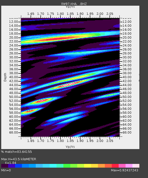
| Estimated Moho Depth: |
43.5 km |
| Estimated Crust Vp/Vs: |
1.84 |
| Assumed Crust Vp: |
6.35 km/s |
| Estimated Crust Vs: |
3.451 km/s |
| Estimated Crust Poisson's Ratio: |
0.29 |
|
| Radial Match: |
83.64155 % |
| Radial Bump: |
400 |
| Transverse Match: |
68.04898 % |
| Transverse Bump: |
400 |
| SOD ConfigId: |
4480 |
| Insert Time: |
2010-02-26 15:34:26.366 +0000 |
| GWidth: |
2.5 |
| Max Bumps: |
400 |
| Tol: |
0.001 |
|

Signal To Noise
| Channel | StoN | STA | LTA |
| XW:KHA: :BHZ:19990109T03:13:54.95501Z | 11.065479 | 1.1914461E-6 | 1.0767235E-7 |
| XW:KHA: :BHN:19990109T03:13:54.95501Z | 5.3907366 | 3.8821372E-7 | 7.201497E-8 |
| XW:KHA: :BHE:19990109T03:13:54.95501Z | 8.522358 | 5.58094E-7 | 6.5485864E-8 |
| Arrivals |
| Ps | 6.1 SECOND |
| PpPs | 18 SECOND |
| PsPs/PpSs | 25 SECOND |


