You are here: Home > Network List > US - United States National Seismic Network Stations List
> Station MSO Missoula, Montana, USA > Earthquake Result Viewer
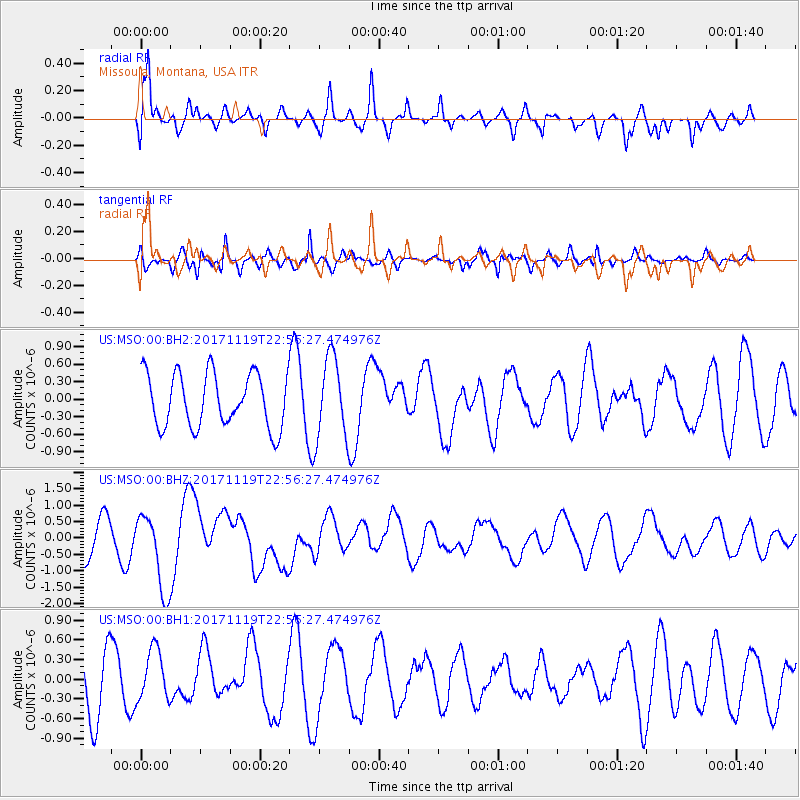
MSO Missoula, Montana, USA - Earthquake Result Viewer
*The percent match for this event was below the threshold and hence no stack was calculated.
| Earthquake location: |
Loyalty Islands |
| Earthquake latitude/longitude: |
-21.3/168.5 |
| Earthquake time(UTC): |
2017/11/19 (323) 22:43:29 GMT |
| Earthquake Depth: |
25 km |
| Earthquake Magnitude: |
7.3 Mi |
| Earthquake Catalog/Contributor: |
NEIC PDE/at |
|
| Network: |
US United States National Seismic Network |
| Station: |
MSO Missoula, Montana, USA |
| Lat/Lon: |
46.83 N/113.94 W |
| Elevation: |
1264 m |
|
| Distance: |
97.2 deg |
| Az: |
42.513 deg |
| Baz: |
246.602 deg |
| Ray Param: |
$rayparam |
*The percent match for this event was below the threshold and hence was not used in the summary stack. |
|
| Radial Match: |
76.95368 % |
| Radial Bump: |
400 |
| Transverse Match: |
71.10497 % |
| Transverse Bump: |
400 |
| SOD ConfigId: |
2429771 |
| Insert Time: |
2017-12-03 22:45:12.661 +0000 |
| GWidth: |
2.5 |
| Max Bumps: |
400 |
| Tol: |
0.001 |
|
Signal To Noise
| Channel | StoN | STA | LTA |
| US:MSO:00:BHZ:20171119T22:56:27.474976Z | 2.6300983 | 1.1649825E-6 | 4.4294254E-7 |
| US:MSO:00:BH1:20171119T22:56:27.474976Z | 0.8726941 | 3.852436E-7 | 4.4144176E-7 |
| US:MSO:00:BH2:20171119T22:56:27.474976Z | 1.5244963 | 6.9759324E-7 | 4.5758935E-7 |
| Arrivals |
| Ps | |
| PpPs | |
| PsPs/PpSs | |


