You are here: Home > Network List > US - United States National Seismic Network Stations List
> Station DGMT Dagmar, Montana, USA > Earthquake Result Viewer
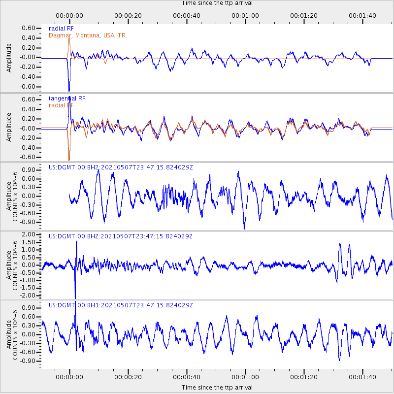
DGMT Dagmar, Montana, USA - Earthquake Result Viewer
*The percent match for this event was below the threshold and hence no stack was calculated.
| Earthquake location: |
Fiji Islands Region |
| Earthquake latitude/longitude: |
-18.8/-177.5 |
| Earthquake time(UTC): |
2021/05/07 (127) 23:35:14 GMT |
| Earthquake Depth: |
384 km |
| Earthquake Magnitude: |
6.1 Mww |
| Earthquake Catalog/Contributor: |
NEIC PDE/us |
|
| Network: |
US United States National Seismic Network |
| Station: |
DGMT Dagmar, Montana, USA |
| Lat/Lon: |
48.47 N/104.20 W |
| Elevation: |
0.0 m |
|
| Distance: |
93.3 deg |
| Az: |
39.679 deg |
| Baz: |
245.338 deg |
| Ray Param: |
$rayparam |
*The percent match for this event was below the threshold and hence was not used in the summary stack. |
|
| Radial Match: |
42.09142 % |
| Radial Bump: |
384 |
| Transverse Match: |
43.954407 % |
| Transverse Bump: |
400 |
| SOD ConfigId: |
24844331 |
| Insert Time: |
2021-05-21 23:59:56.469 +0000 |
| GWidth: |
2.5 |
| Max Bumps: |
400 |
| Tol: |
0.001 |
|
Signal To Noise
| Channel | StoN | STA | LTA |
| US:DGMT:00:BHZ:20210507T23:47:15.824029Z | 3.709535 | 5.5122695E-7 | 1.4859731E-7 |
| US:DGMT:00:BH1:20210507T23:47:15.824029Z | 1.2392131 | 3.560152E-7 | 2.8729133E-7 |
| US:DGMT:00:BH2:20210507T23:47:15.824029Z | 0.69963825 | 2.917689E-7 | 4.1702828E-7 |
| Arrivals |
| Ps | |
| PpPs | |
| PsPs/PpSs | |


