You are here: Home > Network List > US - United States National Seismic Network Stations List
> Station MNTX Cornudas Mountains, Texas, USA > Earthquake Result Viewer
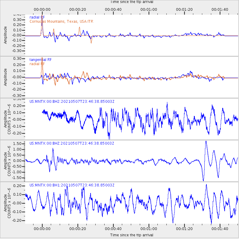
MNTX Cornudas Mountains, Texas, USA - Earthquake Result Viewer
*The percent match for this event was below the threshold and hence no stack was calculated.
| Earthquake location: |
Fiji Islands Region |
| Earthquake latitude/longitude: |
-18.8/-177.5 |
| Earthquake time(UTC): |
2021/05/07 (127) 23:35:14 GMT |
| Earthquake Depth: |
384 km |
| Earthquake Magnitude: |
6.1 Mww |
| Earthquake Catalog/Contributor: |
NEIC PDE/us |
|
| Network: |
US United States National Seismic Network |
| Station: |
MNTX Cornudas Mountains, Texas, USA |
| Lat/Lon: |
31.70 N/105.38 W |
| Elevation: |
404 m |
|
| Distance: |
85.4 deg |
| Az: |
54.469 deg |
| Baz: |
244.736 deg |
| Ray Param: |
$rayparam |
*The percent match for this event was below the threshold and hence was not used in the summary stack. |
|
| Radial Match: |
65.5778 % |
| Radial Bump: |
400 |
| Transverse Match: |
50.704006 % |
| Transverse Bump: |
400 |
| SOD ConfigId: |
24844331 |
| Insert Time: |
2021-05-22 00:00:06.982 +0000 |
| GWidth: |
2.5 |
| Max Bumps: |
400 |
| Tol: |
0.001 |
|
Signal To Noise
| Channel | StoN | STA | LTA |
| US:MNTX:00:BHZ:20210507T23:46:38.85003Z | 3.0204751 | 2.9885962E-7 | 9.8944575E-8 |
| US:MNTX:00:BH1:20210507T23:46:38.85003Z | 0.7918236 | 6.8767896E-8 | 8.684749E-8 |
| US:MNTX:00:BH2:20210507T23:46:38.85003Z | 1.9830222 | 1.2399164E-7 | 6.25266E-8 |
| Arrivals |
| Ps | |
| PpPs | |
| PsPs/PpSs | |


